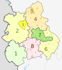
Yorkshire and the Humber counties 2023 map

Dr Greg and Nilfanion. Contains Ordnance Survey data © Crown copyright and database right 2010, CC BY-SA 3.0

Autor/Urheber:
  • Yorkshire and the Humber counties 2009 map.svg: Dr Greg and Nilfanion, contains Ordnance Survey data
  • derivative work: Dr Greg
Größe:
1425 x 1212 Pixel (1144201 Bytes)
Beschreibung:
Map of the Yorkshire and the Humber region of England, showing its counties and administrative districts since 1 April 2023. The county colours are the same as those in File:English metropolitan and non-metropolitan counties 2009.svg.

Equirectangular map projection on WGS 84 datum, with N/S stretched 160%

Geographic limits:

  • West: 2.65°W
  • East: 0.25°E
  • North: 54.65°N
  • South: 53.2N
Lizenz:
Credit:
Diese Datei wurde von diesem Werk abgeleitet: Yorkshire and the Humber counties 2009 map.svg
Bild teilen:
Facebook   Twitter   Pinterest   WhatsApp   Telegram   E-Mail
Weitere Informationen zur Lizenz des Bildes finden Sie hier. Letzte Aktualisierung: Sun, 04 Aug 2024 05:22:34 GMT

Relevante Bilder

Dr Greg and Nilfanion. Contains Ordnance Survey data © Crown copyright and database right 2010, CC BY-SA 3.0
Dr Greg and Nilfanion. Contains Ordnance Survey data © Crown copyright and database right 2011, CC BY-SA 3.0
Dr Greg and Nilfanion. Contains Ordnance Survey data © Crown copyright and database right 2010, CC BY-SA 3.0
The Equalizer, Dr Greg and Nilfanion. Contains Ordnance Survey data © Crown copyright and database right 2010, CC BY-SA 3.0
Dr Greg and Nilfanion. Contains Ordnance Survey data © Crown copyright and database right 2010, CC BY-SA 3.0
Dr Greg and Nilfanion. Contains Ordnance Survey data © Crown copyright and database right 2011, CC BY-SA 3.0
Dr Greg and Nilfanion. Contains Ordnance Survey data © Crown copyright and database right 2010, CC BY-SA 3.0
Nilfanion and Dr Greg. Contains Ordnance Survey data © Crown copyright and database right 2010., CC BY-SA 4.0

Relevante Artikel

Verwaltungsgliederung Englands

Die Verwaltungsgliederung Englands ist letztmals 2021 in einigen Landesteilen reformiert worden. England gliedert sich derzeit in neun Regionen, darunter Greater London. Mit Ausnahme von Greater London sind deren kommunale Einheiten seit 2021 auf drei verschiedene Arten gegliedert:6 Metropolitan Counties, die in insgesamt 36 Metropolitan Boroughs untergliedert sind; 21 Non-Metropolitan Counties, die in insgesamt 164 Districts untergliedert sind ; 63 Unitary Authorities, unter denen die Scilly-Inseln einen Sonderstatus haben. 56 Unitary Authorities haben einen County-Status und sieben haben keinen County-Status. .. weiterlesen