Verwaltungsgliederung Englands

rot: Zweistufige Non-Metropolitan Counties
violett: Metropolitan Counties
orange: Greater London (ohne City of London)
grün: Unitary Authorities
bei Vergrößerung sichtbar: City of London

Die Verwaltungsgliederung Englands ist letztmals 2021 in einigen Landesteilen reformiert worden. England gliedert sich derzeit in neun Regionen, darunter Greater London. Mit Ausnahme von Greater London sind deren kommunale Einheiten seit 2021 auf drei verschiedene Arten gegliedert:
- 6 Metropolitan Counties, die in insgesamt 36 Metropolitan Boroughs untergliedert sind;
- 21 Non-Metropolitan Counties, die in insgesamt 164 Districts untergliedert sind (Gebiete mit zweistufiger Verwaltungsstruktur, siehe auch Liste der Districts in England);
- 63 Unitary Authorities (Gebiete mit einstufiger Verwaltungsstruktur),[1][2] unter denen die Scilly-Inseln einen Sonderstatus haben. 56 Unitary Authorities haben einen County-Status und sieben haben keinen County-Status.
Die Boroughs, Districts und Unitary Authorities können unterschiedliche Zusatztitel haben, die sie entweder aus historischer Zeit führen oder auch in jüngerer Zeit (z. B. wegen ihrer Größe) erhalten haben. Man unterscheidet hierbei zwischen Cities, Boroughs, Metropolitan Boroughs und London Boroughs.
Neben der administrativen Verwaltungsgliederung, deren Ebenen echte politische Kompetenzen besitzen, besteht zudem noch eine rein historisch-symbolische Gliederung, die u. a. umfasst:
- 39 traditionelle Grafschaften, die keine Funktion mehr haben;
- 48 zeremonielle Grafschaften, denen je ein Lord Lieutenant als Vertreter des Monarchen vorsitzt, der aber rein repräsentative Aufgaben hat;
- 2 Herzogtümer, nämlich die Duchy of Cornwall im Privatbesitz des Prince of Wales (Duke of Cornwall) und das Duchy of Lancaster im Privatbesitz des Monarchen (formell verwaltet durch den Chancellor of the Duchy of Lancaster).
Liste der Verwaltungseinheiten Englands
Regionen
| Art | Jahr | Anzahl | Name |
|---|---|---|---|
| Region | 1994 | 9 |
Non-Metropolitan Counties
| Art | Jahr | Anzahl | Name | |
|---|---|---|---|---|
| Non-Metropolitan County | 1974 | 21 | ||
| L | Non-Metropolitan District | 1974 | 164 | siehe Liste der Non-Metropolitan Counties und Non-Metropolitan Districts |
Metropolitan Counties
| Art | Jahr | Anzahl | Name | ||||||
|---|---|---|---|---|---|---|---|---|---|
| Metropolitan County | 1974 | 6 | Greater Manchester | Merseyside | South Yorkshire | Tyne and Wear | West Midlands | West Yorkshire | |
| L | Metropolitan District | 1974 | 36 | ||||||
Greater London
Unitary Authorities
| Art | Jahr | Anzahl | Name |
|---|---|---|---|
| Grafschaft gewann Funktionen eines Distrikts | 2023 | 2 | |
| Distrikte gewannen Funktionen einer Grafschaft | 2023 | 2 | |
| Distrikte gewannen Funktionen einer Grafschaft | 2021 | 2 | |
| Grafschaft gewann Funktionen eines Distrikts | 2020 | 1 | |
| Grafschaft gewann Funktionen eines Distrikts | 2019 | 1 | |
| Distrikte gewannen Funktionen einer Grafschaft | 2019 | 1 | |
| Grafschaft gewann Funktionen eines Distrikts | 2009 | 5 | |
| Distrikte gewannen Funktionen einer Grafschaft | 2009 | 4 | |
| Distrikte gewannen Funktionen einer Grafschaft | 1998 | 15 | |
| Distrikte gewannen Funktionen einer Grafschaft als das Berkshire County Council abgewickelt wurde | 1998 | 6 | |
| Distrikte gewannen Funktionen einer Grafschaft | 1997 | 9 | |
| Distrikte gewannen Funktionen einer Grafschaft | 1996 | 13 | |
| Grafschaft gewann Funktionen eines Distrikts | 1995 | 1 | |
| Sui generis | 1890 | 1 | |
| Gesamt | 63 | ||
Hierarchische Liste der Regionen, Counties und Distrikte
Weblinks
- United Kingdom: Counties and Unitary Authorities. (PDF, 3,5 MB) Office for National Statistics, 2011, abgerufen am 1. Januar 2013 (Übersichtskarte).
Einzelnachweise
- ↑ Local Government Law. Law on the web, 2012, archiviert vom (nicht mehr online verfügbar) am 16. Februar 2013; abgerufen am 1. Januar 2013 (englisch). Info: Der Archivlink wurde automatisch eingesetzt und noch nicht geprüft. Bitte prüfe Original- und Archivlink gemäß Anleitung und entferne dann diesen Hinweis.
- ↑ Office for National Statistics: Counties, Non-metropolitan Districts and Unitary Authorities
Auf dieser Seite verwendete Medien
Flagge des Vereinigten Königreichs in der Proportion 3:5, ausschließlich an Land verwendet. Auf See beträgt das richtige Verhältnis 1:2.
Flagge des Vereinigten Königreichs in der Proportion 3:5, ausschließlich an Land verwendet. Auf See beträgt das richtige Verhältnis 1:2.
Ulster Banner is a heraldic banner taken from the former coat of arms of Northern Ireland. It was used by the Northern Ireland government in 1953-1973 with Edwardian crown since coronation of Queen Elizabeth II, based earlier design with Tudor Crown from 1924. Otherwise known as the Ulster Flag, Red Hand of Ulster Flag, Red Hand Flag.
Ulster Banner is a heraldic banner taken from the former coat of arms of Northern Ireland. It was used by the Northern Ireland government in 1953-1973 with Edwardian crown since coronation of Queen Elizabeth II, based earlier design with Tudor Crown from 1924. Otherwise known as the Ulster Flag, Red Hand of Ulster Flag, Red Hand Flag.
Dr Greg and Nilfanion. Contains Ordnance Survey data © Crown copyright and database right 2010, CC BY-SA 3.0
Map of the North West region of England, showing its counties and administrative districts since 1 April 2023. The county colours are the same as those in File:English metropolitan and non-metropolitan counties 2009.svg.
Equirectangular map projection on WGS 84 datum, with N/S stretched 160%
Geographic limits:
- West: 3.8°W
- East: 1.8°W
- North: 55.25°N
- South: 52.9°N
Autor/Urheber: XrysD, Lizenz: CC BY 3.0
Administrative map of England.
Verwaltungsgliederung in England
Dr Greg and Nilfanion. Contains Ordnance Survey data © Crown copyright and database right 2011, CC BY-SA 3.0
Map of the North East England region of England, showing its counties and administrative districts. The county colours are the same as those in File:English metropolitan and non-metropolitan counties 2009.svg.
Equirectangular map projection on WGS 84 datum, with N/S stretched 170% Geographic limits:
- West: 2.75W
- East: 0.7W
- North: 55.9N
- South: 54.4N
The Equalizer, Dr Greg and Nilfanion. Contains Ordnance Survey data © Crown copyright and database right 2010, CC BY-SA 3.0
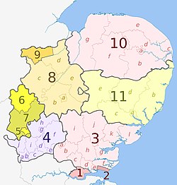
Map of the East of England region, showing its counties and administrative districts. The county colours are the same as those in File:English metropolitan and non-metropolitan counties 2009.svg.
Equirectangular map projection on WGS 84 datum, with N/S stretched 160%
Geographic limits:
- West: 0.8W
- East: 1.8E
- North: 53.1N
- South: 51.4N
Dr Greg and Nilfanion. Contains Ordnance Survey data © Crown copyright and database right 2010, CC BY-SA 3.0
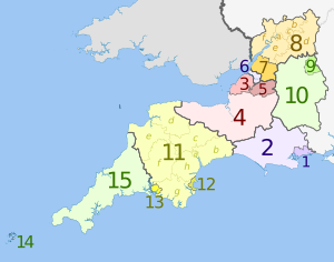
Map of the South West region of England, showing its counties and administrative districts since 1 April 2023. The county colours are the same as those in File:English metropolitan and non-metropolitan counties 2009.svg.
Equirectangular map projection on WGS 84 datum, with N/S stretched 160%
Geographic limits:
- West: 6.5°W
- East: 1.4°W
- North: 52.2°N
- South: 49.7°N
Dr Greg and Nilfanion. Contains Ordnance Survey data © Crown copyright and database right 2010, CC BY-SA 3.0
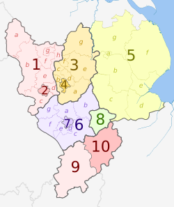
Map of the East Midlands region, showing its counties and administrative districts since 1 April 2021. The county colours are the same as those in File:English metropolitan and non-metropolitan counties 2009.svg.
Equirectangular map projection on WGS 84 datum, with N/S stretched 160%
Geographic limits:
- West: 2.1°W
- East: 0.4°E
- North: 53.7°N
- South: 51.9°N
Dr Greg and Nilfanion. Contains Ordnance Survey data © Crown copyright and database right 2010, CC BY-SA 3.0
Map of the South East region of England, showing its counties and administrative districts since 1 April 2020. The county colours are the same as those in File:English metropolitan and non-metropolitan counties 2009.svg.
Equirectangular map projection on WGS 84 datum, with N/S stretched 160%
Geographic limits:
- West: 2.0°W
- East: 1.5°E
- North: 52.25°N
- South: 50.5°N
Nilfanion and Dr Greg. Contains Ordnance Survey data © Crown copyright and database right 2010., CC BY-SA 4.0
Map showing the Regions of England and the constituent metropolitan and non-metropolitan counties from 1 April 2023.
Equirectangular map projection on WGS 84 datum, with N/S stretched 170%
Geographic limits:
- West: 6.75°W
- East: 2.0°E
- North: 56.0°N
- South: 49.75°N
Changes since the 2021 version:
- New unitary authority areas:
- Key
Dr Greg and Nilfanion. Contains Ordnance Survey data © Crown copyright and database right 2010, CC BY-SA 3.0
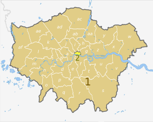
Map of Greater London, UK with districts shown, in the same style as other maps of English regions. The county colours are the same as those in File:English metropolitan and non-metropolitan counties 2009.svg.
Equirectangular map projection on WGS 84 datum, with N/S stretched 160%. Geographic limits:
- West: 0.57W
- East: 0.37E
- North: 51.72N
- South: 51.25N
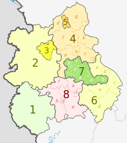
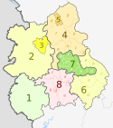
Dr Greg and Nilfanion. Contains Ordnance Survey data © Crown copyright and database right 2011, CC BY-SA 3.0
Map of the West Midlands region of England, showing its counties and administrative districts. The county colours are the same as those in File:English metropolitan and non-metropolitan counties 2009.svg.
Equirectangular map projection on WGS 84 datum, with N/S stretched 165% Geographic limits:
- West: 3.3W
- East: 1.1W
- North: 53.25N
- South: 51.75N
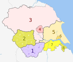
Dr Greg and Nilfanion. Contains Ordnance Survey data © Crown copyright and database right 2010, CC BY-SA 3.0
Map of the Yorkshire and the Humber region of England, showing its counties and administrative districts since 1 April 2023. The county colours are the same as those in File:English metropolitan and non-metropolitan counties 2009.svg.
Equirectangular map projection on WGS 84 datum, with N/S stretched 160%
Geographic limits:
- West: 2.65°W
- East: 0.25°E
- North: 54.65°N
- South: 53.2N

