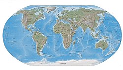
Tissot indicatrix world map Robinson proj
Attribution:
Das Bild ist mit 'Attribution Required' markiert, aber es wurden keine Informationen über die Attribution bereitgestellt. Vermutlich wurde bei Verwendung des MediaWiki-Templates für die CC-BY Lizenzen der Parameter für die Attribution weggelassen. Autoren und Urheber finden für die korrekte Verwendung der Templates hier ein Beispiel.
Shortlink:
Quelle:
Größe:
3000 x 1522 Pixel (1555941 Bytes)
Beschreibung:
Map of the world in a Robinson projection with Tissot's Indicatrix of deformation.
Each red circle/ellipse has a radius of 500 km.
Scale : 1:5,000,000
Each red circle/ellipse has a radius of 500 km.
Scale : 1:5,000,000
Kommentar zur Lizenz:
| Attribution and Share-Alike required |
|---|
| Any use of this map can be made as long as you credit me (Eric Gaba – Wikimedia Commons user: Sting) as the author and distribute the copies and derivative works under the same license(s) that the one(s) stated below. A message with a reply address would also be greatly appreciated. |
Lizenz:
Credit:
Eigenes Werk
- Data : U.S. NGDC World Coast Line (public domain)
Relevante Bilder
Relevante Artikel
Gall-Peters-ProjektionDie Peters-Projektion ist ein von Arno Peters 1974 veröffentlichter Kartennetzentwurf. Er erreichte zunächst eine vermehrte Verwendung und erzielte anhaltende Aufmerksamkeit. Der von Peters eigenständig entwickelte Entwurf ist im Ergebnis mit der von James Gall (1808–1895) entwickelten Gall-Peters-Projektion identisch. .. weiterlesen
Robinson-ProjektionDie Robinson-Projektion ist ein Kartennetzentwurf, der 1961 von dem US-amerikanischen Kartographen Arthur H. Robinson entwickelt wurde. .. weiterlesen


