The Bell System technical journal (1922) (14753547484)
Identifier: bellvol36systemtechni00amerrich (find matches)
Title: The Bell System technical journal
Year: 1922 (1920s)
Authors: American Telephone and Telegraph Company
Subjects: Telecommunication Electric engineering Communication Electronics Science Technology
Publisher: (Short Hills, N.J., etc., American Telephone and Telegraph Co.)
Contributing Library: Prelinger Library
Digitizing Sponsor: Internet Archive
View Book Page: Book Viewer
About This Book: Catalog Entry
View All Images: All Images From Book
Click here to view book online to see this illustration in context in a browseable online version of this book.
Text Appearing Before Image:
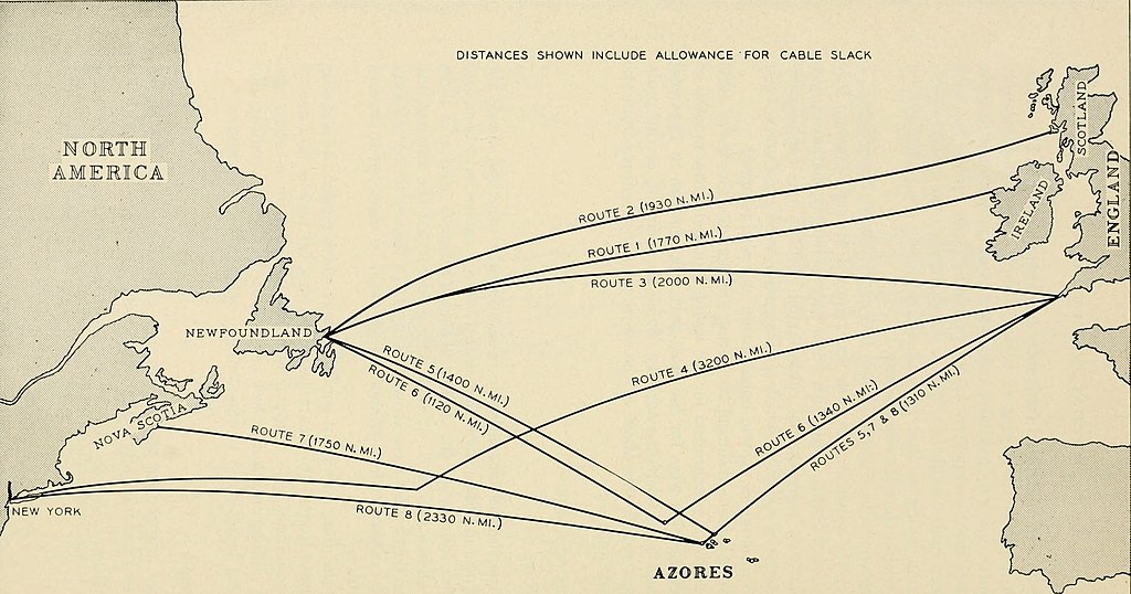
at date 15 direct cables have been laidand 5 cables by way of the Azores. The approximate routes of thesecables are shown in Fig. 1. It is at once evident that the shortest andpossibly the best routes were already occupied so that selection of routesfor the two transatlantic telephone cables could be expected to presentsome difficulty. Some of the more important considerations which guided the selectionwere (a) route length, (b) clearance for repairs, (c) trawler and anchordamage possibilities, (d) terminal locations suitable for repeater sta-tions, with staffing in mind as well as facifities for onward routing, dueconsideration being given to the strategic aspects of the locations. Route Length Obviously, the shorter the length of a submarine route, the better.In the present instance, any system length much in excess of about 2,000 * Two additional repeaters are located in the 55 nautical-mile section which istrenched in across Newfoundland from Clarenville to Terrenceville. aMVlONSI
Text Appearing After Image:
01 J2c3 o oao a -tJ Q)> aH I (N d 296 ROUTE SELECTION AND CABLE LAYING 297 nautical miles would have resulted in a reduction in the number of voicechannels which could be derived from the facility. On Fig. 2 are shown a number of the routes to which considerationwas given in the early planning stages. The distances shown are actualcable lengths and include an allowance for the slack necessary to assureconformance of the cable to the profile of the ocean bottom. Route 1, from Eire to Newfoundland, at 1,770 miles, is the shortestroute and in point of fact was provisionally suggested in 1930 for a newcable. But the difficulty of onward transmission of traffic to Londonmade this route unattractive. Route 2, from Newfoundland to Scotland, compared favorably inlength with Route 1, but its adoption was dependent upon location ofa suitable landing site in Scotland. Route 3, from Newfoundland to Cornwall, England, approximated2,000 miles laid length and would have been very attractive had n
Note About Images
Relevante Bilder
Relevante Artikel
TAT-1TAT-1 war das erste transatlantische Telefonkabelsystem. Es liegt zwischen Oban in Schottland und Clarenville in Neufundland. Das Kabel wurde am 25. September 1956 in Betrieb genommen. .. weiterlesen

