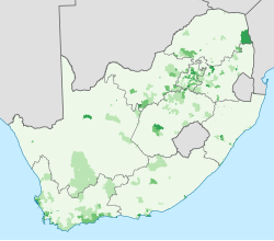
South Africa 2011 Indian or Asian population proportion map
Autor/Urheber:
Shortlink:
Quelle:
Größe:
809 x 709 Pixel (349215 Bytes)
Beschreibung:
Map showing the proportion of the South African population that self-described as "Indian or Asian" in the 2011 census, at electoral ward level.
0–20%
20–40%
40–60%
60–80%
80–100%
Projection is Albers Equal-Area Conic, with standard parallels at 25.5° S and 31.5° S, and origin at 28.5° S 25.5° E.
Lizenz:
Public domain
Credit:
Statistics South Africa's Census 2011 is the source of the basic population data. The map results from my own processing of the data. For ward boundaries see File:South Africa electoral wards 2011 blank.svg.
Relevante Bilder
Relevante Artikel
Demografie SüdafrikasDie Demografie Südafrikas ist sehr heterogen, das Land gilt als eines der ethnisch-demografisch vielfältigsten Länder des afrikanischen Kontinents. Südafrika ist die Heimat verschiedener afrikanischer Gesellschaften sowie der Nachfahren vorwiegend niederländischer, deutscher, französischer, asiatischer und britischer Einwanderer. Südafrika ist damit ein multikulturelles Land und wird oft als „Regenbogennation“ bezeichnet. .. weiterlesen


