Satellite image of France in August 2002
Autor/Urheber:
Jacques Descloitres, MODIS Rapid Response Team, NASA/GSFC
Shortlink:
Quelle:
Größe:
5200 x 4000 Pixel (3936708 Bytes)
Beschreibung:
Satellite image of France acquired August 14, 2002, by the Terra satellite.
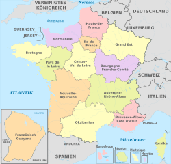
- An unusually cloud-free France shows green and tan in this true-color Moderate Resolution Imaging Spectroradiometer (MODIS) image acquired August 14, 2002, by the Terra satellite. The great city of Paris is visible in the upper center of the image as a gray smudge against the landscape, and is even clearer in the higher resolutions of this image.
- To the north, clouds mostly obscure the English Channel, but the Bay of Biscay to the west is clear, as is the Mediterranean Sea to the south. The northernmost portion of Spain is clearly visible at the bottom of the image, and is separated from France by the Pyrenees Mountain Range.
Lizenz:
Public domain
Credit:
Slightly cropped image. Original taken from NASA's Visible Earth: [1].
Credit: Jacques Descloitres, MODIS Rapid Response Team, NASA/GSFC
Credit: Jacques Descloitres, MODIS Rapid Response Team, NASA/GSFC
Relevante Bilder
Relevante Artikel
Französischer WaldDie Waldfläche Frankreichs umfasst 16,3 Millionen Hektar. Dies sind 29,7 % der Gesamtfläche des Landes. Zählt man die Waldfläche der französischen Überseegebiete noch hinzu, beträgt sie 246.640 km², also 36,7 % der gesamten Fläche, die zu Frankreich gehört. .. weiterlesen
Geographie FrankreichsAls interkontinentaler Staat liegt Frankreich in mehreren Kontinenten. .. weiterlesen


