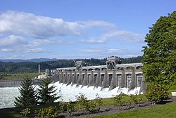
Rock Island Dam, Columbia River, Washington (4866941384)
Photographer:
Unknown
Subjects (LCSH):
Rock Island Dam (Wash.)--Aerial photographs
Dams--Washington (State)--Aerial photographs
Columbia River--Aerial photographs
Rivers--Washington (State)
Aluminum Company of America
Klokuk Electro Metals Company
Digital Collection:
Washington Localities Collection
http://content.lib.washington.edu/wastateweb/index.html
Item Number: WAS0880
Persistent URL:
http://content.lib.washington.edu/u?/wastate,1099
Visit Special Collections http://www.lib.washington.edu/specialcoll/service/reproduction.html page for information on ordering a copy.
Relevante Bilder
Relevante Artikel
Rock Island DamDer Rock Island Dam ist eine Talsperre am Columbia River zwischen dem Chelan County und Douglas County im Bundesstaat Washington der USA, 19 km flussabwärts von Wenatchee und 729 km flussaufwärts von der Mündung des Columbia bei Astoria gelegen. Die Talsperre hat eine s-förmige Beton-Gewichtsstaumauer mit zwei Laufwasserkraftwerken und staut seit 1933 den Columbia zum Rock Island Pool auf, der sich 33 km flussaufwärts bis zum Rocky Reach Dam im Norden erstreckt. Der Stausee wird zusätzlich vom Wenatchee River gespeist, einem Nebenfluss, der oberhalb von Wenatchee in den Columbia mündet. Beide Talsperren sind Teil mehrerer Staustufen am Columbia und werden vom Chelan County Public Utility District betrieben. .. weiterlesen


