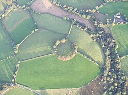
Rath near Clanabogan Community Centre - geograph.org.uk - 93330

(c) Kenneth Allen, CC BY-SA 2.0

Autor/Urheber:
Größe:
640 x 479 Pixel (165833 Bytes)
Beschreibung:
Rath near Clanabogan Community Centre. The Camphill farm adjoins this rath. I was able to get this view looking down on it from the first floor of a farm building. It gives you a good indication of the circular shape. I had a chat with one of the volunteer workers who came from Germany, and he informs me that he has come for a year to take part in the eco-friendly farming activities and help disabled people who attend or live in the campus.
Lizenz:
Credit:
Bild teilen:
Facebook   Twitter   Pinterest   WhatsApp   Telegram   E-Mail
Weitere Informationen zur Lizenz des Bildes finden Sie hier. Letzte Aktualisierung: Mon, 31 Jul 2023 00:50:43 GMT

Relevante Bilder

(c) Kenneth Allen, CC BY-SA 2.0
(c) Gordon Dunn, CC BY-SA 2.0
(c) Albert Bridge, CC BY-SA 2.0
(c) Aubrey Dale, CC BY-SA 2.0

Relevante Artikel

Ráth (Erdwerk)

In der Archäologie bezeichnet Ráth ein eisenzeitliches oder älteres irisches Erdwerk. Ráths sind kreisrund oder oval und von unterschiedlicher Größe. Durchmesser von 20 m sind häufig, sie können aber, wie beim 2005 bei Derry in Nordirland ausgegrabenen Ráth, auch 100 m weit sein und im Einzelfall auch zum Quadrat abweichen. Sie werden auch „Fairy fort“ (Feenburg) genannt, was auf eine religiöse Bedeutung als Temene hinweist. Die Bezeichnung findet sich auch in Wales, wo der Rudbaxton Rath und der „Walwyn’s Castle Ráth“ in Pembrokeshire liegen. .. weiterlesen