Radar loop of Typhoon Haiyan (Yolanda) making landfall on Leyte Island
Autor/Urheber:
PAGASA
Shortlink:
Quelle:
_making_landfall_on_Leyte_Island.gif?uselang=de)
Größe:
622 x 622 Pixel (1180968 Bytes)
Beschreibung:
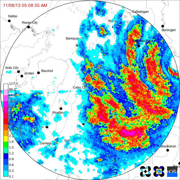
Loop of doppler radar imagery showing Typhoon Yolanda/Haiyan's second Philippine landfall, on the island of Leyte. The PAGASA Cebu City radar site began to transmit intermittently as the typhoon neared, eventually failing altogether (last frame).
- 5:08AM - The northern eye of Haiyan making landfall on the village of Guiuan, which blows the dome off Guiuan radar station. Crosses into the Leyte Gulf shortly thereafter.
- 7:00AM - Landfall on the island of Leyte. The northern eyewall, the most powerful part of the storm, hits Tacloban City.
- 8:06AM - Northern portion of Haiyan's central core collapses while crossing over Leyte's Nacolod mountain range, though still remaining a category 5 storm. Eye overhead of Ormoc City.
- 9:33AM - Haiyan on the Cebu Strait, immediately before making landfall on the island of Cebu.
Lizenz:
Public domain
Credit:
Bild teilen:


Relevante Bilder


.png)


Relevante Artikel
Taifun HaiyanTaifun Haiyan, internationale Bezeichnung 1330, auf den Philippinen Taifun Yolanda, war der 30. tropische Wirbelsturm und 13. Taifun der Pazifischen Taifunsaison 2013 und einer der stärksten tropischen Wirbelstürme, die seit Beginn verlässlicher Wetteraufzeichnungen beobachtet wurden. Haiyan verursachte große Schäden und führte zum Tod von mehr als 7300 Menschen. Am stärksten betroffen waren die Inseln der Visayas-Gruppe der zentralen Philippinen. .. weiterlesen