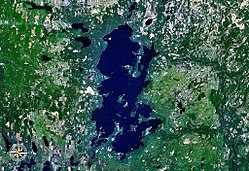
Omulyakhskaya and Khromskaya Bays, Northern Siberia
Autor/Urheber:
Jesse Allen and Robert Simmon
Größe:
4696 x 3131 Pixel (4920756 Bytes)
Beschreibung:
Natural-colour image of the Omulyakhskaya and Khromskaya Bays, Russia. The land around the bays is dotted with thermokarst lakes, which result from
water released by thawing
permafrost. The water in a thermokarst lake doesn’t always stay put; these lakes can melt through the surrounding permafrost and drain into a nearby water body, especially if it sits at a slightly lower elevation. This appears to have occurred in multiple lakes between the bays shown above. (The compound lakes are identifiable by their uneven margins.)
Coastal erosion and
river migration also can deplete the lakes. Dark
brown spots, especially numerous east of Khromskaya Bay, are probably locations of former thermokarst lakes.
Image captured by the Thematic Mapper on the Landsat 5 satellite. Landsat data provided by the United States Geological Survey.
Weitere Informationen zur Lizenz des Bildes finden Sie hier. Letzte Aktualisierung: Sat, 04 Nov 2023 00:24:26 GMT
Relevante Bilder
Relevante Artikel
Welterbe in Russland
Zum Welterbe in Russland gehören 31 UNESCO-Welterbestätten, darunter 20 Stätten des Weltkulturerbes und 11 Stätten des Weltnaturerbes. Darunter sind mit dem Struve-Bogen, der Kurischen Nehrung und den Daurischen Landschaften drei grenzüberschreitende oder transnationale Welterbestätten. Die Sowjetunion, deren Rechtsnachfolger Russland ist, hat die Welterbekonvention 1988 ratifiziert, die ersten drei Welterbestätten Russlands wurden 1990 in die Welterbeliste aufgenommen. Die bislang letzte Welterbestätte wurde 2023 in die Liste aufgenommen.
.. weiterlesen


