NASA - Visible Earth, Lakes of the African Rift Valley
Autor/Urheber:
SeaWiFS Project, NASA/Goddard Space Flight Center, and ORBIMAGE
Shortlink:
Quelle:
Größe:
1000 x 654 Pixel (129920 Bytes)
Beschreibung:
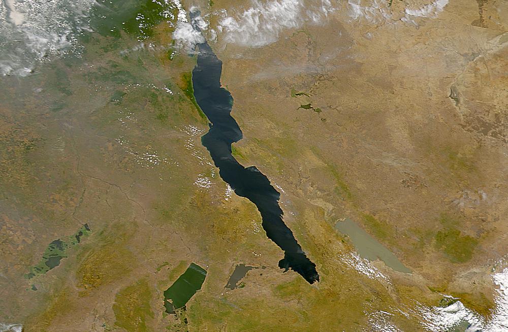
The lakes of the African Rift Valley exhibit wide variations in water color as can be seen in this SeaWiFS image. From left to right the lakes are: Lake Upembe, Lake Mweru, Lake Tanganyika (largest), and Lake Rukwa. This image spans the southeastern corner of the Democratic Republic of the Congo, northeastern Zambia, and southern Tanzania.
Lizenz:
Public domain
Bild teilen:


Relevante Bilder


_Kneller%40Residenzmuseum_Celle20160708.jpg)


(c) Bundesarchiv, Bild 183-Z0309-310 / G. Beyer / CC-BY-SA 3.0


(c) Bundesarchiv, B 145 Bild-F015051-0008 / Patzek, Renate / CC-BY-SA 3.0


(c) Holger Motzkau 2010, Wikipedia/Wikimedia Commons (cc-by-sa-3.0)


.jpg)

© Sémhur / Wikimedia Commons, CC BY-SA 4.0
.jpg)

(c) Eric Gaba, Wikimedia Commons user Sting, CC BY-SA 3.0


Relevante Artikel
Katavi (Region)Katavi liegt im Westen von Tansania und ist eine der insgesamt 31 Regionen des Staates. Im Südwesten hat Katavi Anteil am Tanganjikasee, im Südosten grenzt es an den Rukwasee. Die Regions-Hauptstadt ist Mpanda. .. weiterlesen
TanganjikaseeDer Tanganjikasee ist der zweitgrößte See in Afrika und der sechstgrößte sowie der zweittiefste See der Erde. Er liegt in den Staaten Demokratische Republik Kongo, Tansania, Sambia und Burundi. .. weiterlesen
13. FebruarDer 13. Februar ist der 44. Tag des gregorianischen Kalenders, somit bleiben 321 Tage bis zum Jahresende. .. weiterlesen