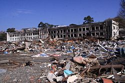
Miyagi - Ishinomaki -- Onosaki and Nagatsura -a- Tsunami heights -b and c- View of tsunami damage and ground subsidence
Autor/Urheber:
Yoshinobu Tsuji, Kenji Satake, Takeo Ishibe, Tomoya Harada, Akihito Nishiyama, Satoshi Kusumoto: "Tsunami Heights along the Pacific Coast of Northern Honshu Recorded from the 2011 Tohoku", Pure and Applied Geophysics, 171, 12, (2014), pp. 3183–3215, DOI:10.1007/s00024-014-0779-x, online published on 19 March 2014. License: Creative Commons Attribution 4.0 International (CC BY 4.0). Here p. 3191, Figure 9.
Attribution:
Das Bild ist mit 'Attribution Required' markiert, aber es wurden keine Informationen über die Attribution bereitgestellt. Vermutlich wurde bei Verwendung des MediaWiki-Templates für die CC-BY Lizenzen der Parameter für die Attribution weggelassen. Autoren und Urheber finden für die korrekte Verwendung der Templates hier ein Beispiel.
Shortlink:
Quelle:
Größe:
2748 x 2605 Pixel (939315 Bytes)
Beschreibung:
Source: Yoshinobu Tsuji, Kenji Satake, Takeo Ishibe, Tomoya Harada, Akihito Nishiyama, Satoshi Kusumoto: "Tsunami Heights along the Pacific Coast of Northern Honshu Recorded from the 2011 Tohoku", Pure and Applied Geophysics, 171, 12, (2014), pp. 3183–3215, DOI:10.1007/s00024-014-0779-x, online published on 19 March 2014. License: Creative Commons Attribution 4.0 International (CC BY 4.0). Here p. 3191, Figure 9.
Caption as given in the above cited source: "a Tsunami heights at Onosaki (M43, M46) and Nagatsura (M44, M45, M47, and M48), Ishinomaki City, Miyagi Prefecture. The symbols and their meanings are the same as in Fig. 3. b, c View of tsunami damage and ground subsidence at Onosaki and Nagatsura"
Context as given in the above cited source: "Around Nagazuraura, which is a brackish lake connected to Oppa Bay in Ishinomaki City, almost all the houses were inundated by the 2011 tsunami (Fig. 9). Japanese black pines and houses at the mouth of the Kitakami River were swept away. Many houses and rice paddies were submerged due to significant ground subsidence, and sand was deposited all over the residential district. In Onosaki district, which is located eastward of Nagazuraura, inundation heights of 4.2 and 3.9 m were measured (M43, M46). In Nagatsura district to the west of Nagazuraura, four inundation heights ranging 4.1–7.1 m were obtained (M44, M45, M47 and M48). Some residents drowned at the temple to which they had evacuated, erroneously assuming it was at a safe elevation."
Kommentar zur Lizenz:
Diese Datei ist lizenziert unter der Creative-Commons-Lizenz „Namensnennung 4.0 international“.
- Dieses Werk darf von dir
- verbreitet werden – vervielfältigt, verbreitet und öffentlich zugänglich gemacht werden
- neu zusammengestellt werden – abgewandelt und bearbeitet werden
- Zu den folgenden Bedingungen:
- Namensnennung – Du musst angemessene Urheber- und Rechteangaben machen, einen Link zur Lizenz beifügen und angeben, ob Änderungen vorgenommen wurden. Diese Angaben dürfen in jeder angemessenen Art und Weise gemacht werden, allerdings nicht so, dass der Eindruck entsteht, der Lizenzgeber unterstütze gerade dich oder deine Nutzung besonders.
Lizenz:
Credit:
Yoshinobu Tsuji, Kenji Satake, Takeo Ishibe, Tomoya Harada, Akihito Nishiyama, Satoshi Kusumoto: "Tsunami Heights along the Pacific Coast of Northern Honshu Recorded from the 2011 Tohoku", Pure and Applied Geophysics, 171, 12, (2014), pp. 3183–3215, DOI:10.1007/s00024-014-0779-x, online published on 19 March 2014. License: Creative Commons Attribution 4.0 International (CC BY 4.0). Here p. 3191, Figure 9.
Relevante Bilder


(c) Anawat Suppasri, Nobuo Shuto, Fumihiko Imamura, Shunichi Koshimura, Erick Mas, Ahmet Cevdet Yalciner, CC BY 2.0


(c) Anawat Suppasri, Nobuo Shuto, Fumihiko Imamura, Shunichi Koshimura, Erick Mas, Ahmet Cevdet Yalciner, CC BY 2.0

(c) Anawat Suppasri, Nobuo Shuto, Fumihiko Imamura, Shunichi Koshimura, Erick Mas, Ahmet Cevdet Yalciner, CC BY 2.0


(c) Anawat Suppasri, Nobuo Shuto, Fumihiko Imamura, Shunichi Koshimura, Erick Mas, Ahmet Cevdet Yalciner, CC BY 2.0


Relevante Artikel
IshinomakiIshinomaki ist eine Großstadt in der Präfektur Miyagi auf Honshū, der Hauptinsel von Japan. .. weiterlesen
