Marcellus shale isobath map 2019 DE
Autor/Urheber:
Attribution:
Das Bild ist mit 'Attribution Required' markiert, aber es wurden keine Informationen über die Attribution bereitgestellt. Vermutlich wurde bei Verwendung des MediaWiki-Templates für die CC-BY Lizenzen der Parameter für die Attribution weggelassen. Autoren und Urheber finden für die korrekte Verwendung der Templates hier ein Beispiel.
Shortlink:
Quelle:
Größe:
3507 x 2480 Pixel (5078116 Bytes)
Beschreibung:
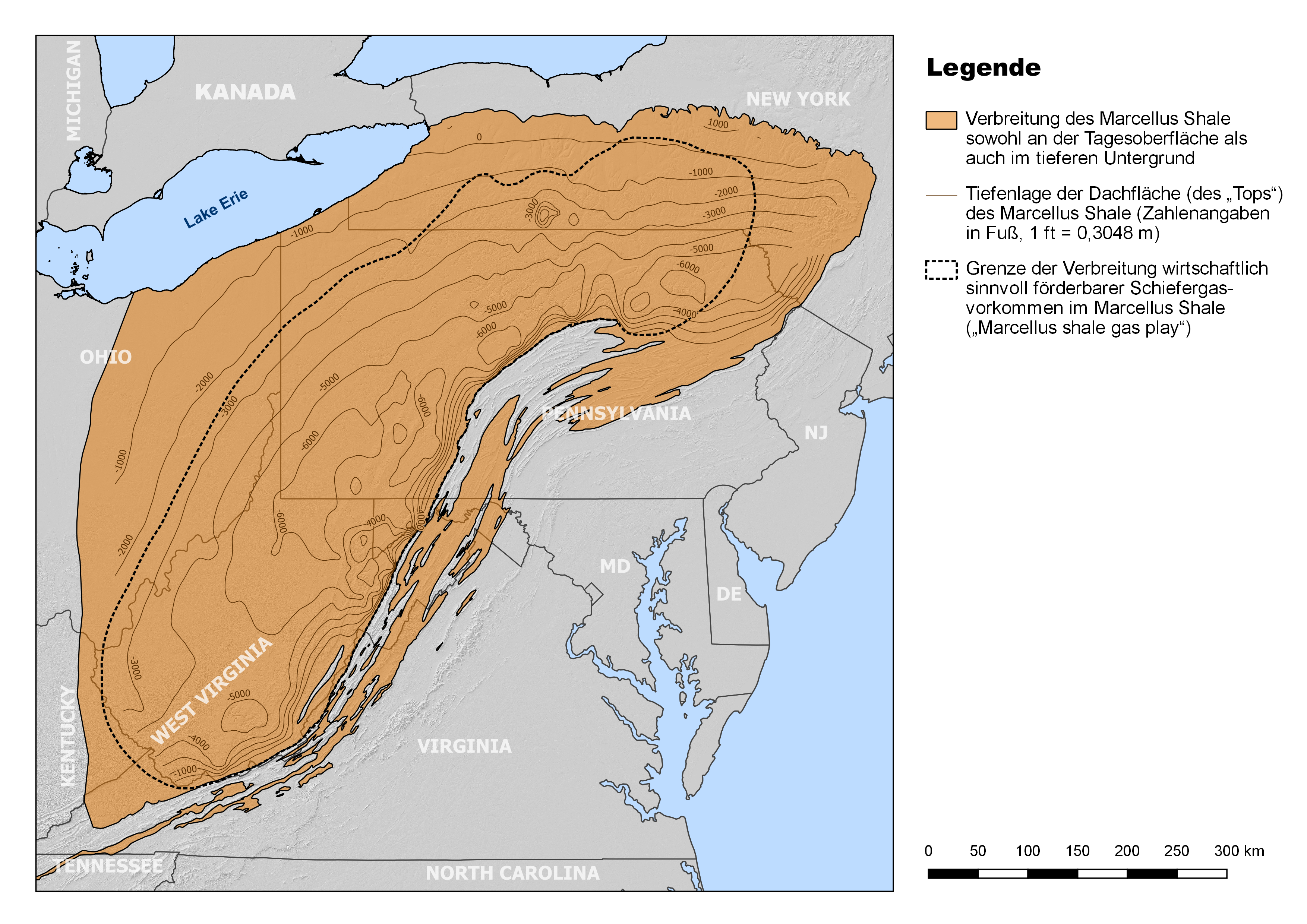
Verbreitung des mitteldevonischen Marcellus Shale im Nordosten der USA (Appalachenbecken) mit Verzeichnung der Tiefenlage der Dachfläche (engl. „Top“) der Formation (Angaben in Fuß bzgl. Meeresspiegelniveau). Wie der Karte zu entnehmen ist, liegt der weit überwiegende Teil der Formation unterhalb der Tagesoberfläche, mit Tiefenmaxima von mehr als 6000 ft (> 1800 m) nahe der Alleghenischen Front. Letztgenannte ist zudem annähernd deckungsgleich mit der östlichen Grenze des „Marcellus shale gas play“.
Lizenz:
Credit:
Eigenes Werk
The map was created using QGIS, with minor revisions using Adobe Photoshop.
Data sources:
- Geology: shapefile ‘Tight Oil and Shale Gas by Individual Play’ (March 2019), provided by the U.S. Energy Information Administration (download URL: https://www.eia.gov/maps/map_data/TightOil_ShaleGas_IndividualPlays_Lower48_EIA.zip)
- State and country borders: shapefiles (2018) provided by the U.S. Census Bureau (download URLs: https://www2.census.gov/geo/tiger/GENZ2018/shp/cb_2018_us_state_5m.zip, https://www2.census.gov/geo/tiger/GENZ2018/shp/cb_2018_us_nation_5m.zip)
- Geographical features (large lakes only): a selection of OpenStreetMap data (shapefiles, as of 21 August 2019), provided at Geofabrik (http://download.geofabrik.de/north-america.html)
- Background: hillshade layer, generated from SRTM-based (SRTM GL3, 90 m resolution) digital elevation model, all provided at OpenTopography (http://opentopo.sdsc.edu/raster?opentopoID=OTSRTM.042013.4326.1)
Bild teilen:


Relevante Bilder

(c) Ruhrfisch, CC BY-SA 4.0
Relevante Artikel
Marcellus-FormationDie Marcellus-Formation ist eine lithostratigraphische Einheit mariner Sedimentgesteine des Mittel-Devons im östlichen Nordamerika. Benannt ist die Formation nach einem Aufschluss in der Nähe des Dorfes Marcellus im US-Bundesstaat New York. Sie erstreckt sich auf einer Fläche von knapp 250.000 Quadratkilometern vor allem über die US-Bundesstaaten New York, Pennsylvania, Ohio und West Virginia, wobei sie im weit überwiegenden Teil dieses Gebietes tief im Untergrund des Appalachen-Plateaus verborgen liegt. .. weiterlesen