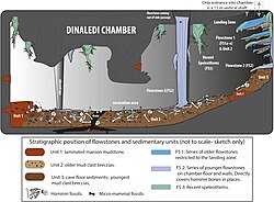
Map of the Dinaledi Chamber showing distribution of hominin fossils
Autor/Urheber:
Paul H. G. M. Dirks et al
Attribution:
Das Bild ist mit 'Attribution Required' markiert, aber es wurden keine Informationen über die Attribution bereitgestellt. Vermutlich wurde bei Verwendung des MediaWiki-Templates für die CC-BY Lizenzen der Parameter für die Attribution weggelassen. Autoren und Urheber finden für die korrekte Verwendung der Templates hier ein Beispiel.
Shortlink:
Quelle:
Größe:
3487 x 2924 Pixel (437024 Bytes)
Beschreibung:
Map of the cave chamber showing the distribution of hominin fossils.
(A) distribution of concentrations of bone fragments of H. naledi along the floor of the Dinaledi Chamber. The positions of maps (B) and (C), (D) are shown relative to survey pegs 1 and 2 respectively. (B) Concentration of long bone fragments encountered next to a rock embedded in Unit 3 sediment. (C) Distribution of fossils in the excavation pit at the start of the excavations in November 2013 (∼5 cm below surface). (D) Distribution of fossils in the excavation pit during excavations in March 2014 (∼15 cm below surface); the long-bone in the central part of the pit is in a near-vertical position and is shown in Figure 9C.
Lizenz:
Relevante Bilder
Relevante Artikel
Rising-Star-HöhleDie Rising-Star-Höhle ist eine südafrikanische Fundstätte von Fossilien im Gebiet des UNESCO-Welterbes Cradle of Humankind, unweit von Krugersdorp. Im September 2013 wurde in dem Höhlensystem eine Passage entdeckt, die „zu einer spektakulären Fundstelle von Homininenknochen“ führt. .. weiterlesen


