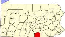
Map of Adams County Pennsylvania With Municipal and Township Labels
Autor/Urheber:
Shortlink:
Quelle:
Größe:
509 x 386 Pixel (44518 Bytes)
Beschreibung:
Map of Adams County, Pennsylvania, United States with township and municipal boundaries is taken from US Census website [1] and modified by User:Ruhrfisch in April 2006. My modifications licensed under the GNU Free Documentation License.
Source: US Census website [2]
Lizenz:
Public domain
Relevante Bilder
Relevante Artikel
Adams County (Pennsylvania)Das Adams County ist ein County im US-Bundesstaat Pennsylvania. Bei der Volkszählung im Jahr 2020 hatte das County 103.852 Einwohner und eine Bevölkerungsdichte von 77,1 Einwohnern pro Quadratkilometer. Der Verwaltungssitz ist Gettysburg. .. weiterlesen


