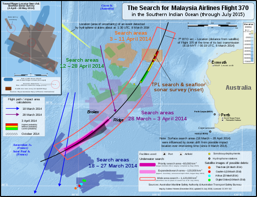
MH370 SIO search through Nov 2014
Not shown:
- A Japanese satellite spotted 10 objects possibly related to Flight 370. No coordinates for these objects could be found online; therefore, they haven't been included in the map.
- The bathymetric survey (ongoing). The map released by the JACC showing the areas surveyed is in a different projection and can't easily be included in this map.
Eigenes Werk The following sources were used for data included in the map. Locations (eg. where the search was conducted, locations of satellite debris & acoustic detections) are factual information which is not subject to copyright. Most sources are noted in the map.
Main map
- Search locations, sonobouy deployments, & calculated flight paths:
- Australia Maritime Safety Authority ("Cumulative area searched (handout)" maps from the MH370 Search - Media kit; 18 March-11 April)
- Joint Agency Coordination Centre (Media Releases—2014; Maps found at the bottom of "Search continues for Malaysian flight MH370" media releases)
- Possible debris satellite images (coordinates):
- 3 April probable impact areas:
- Australian Transport Safety Bureau – MH370 – Definition of Underwater Search Areas - Figure 5: Red, yellow and green boxes within S4-S5 and M641 route (pg. 7; source: Joint Investigation Team)
- October probable impact area:
- Australian Transport Safety Bureau – MH370 – Flight Path Analysis Update - Figures 3 & 5 (pgs. 10 & 12; source: Flight path reconstruction group)
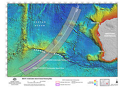
- Underwater search
- MH370 Underwater Search Areas Planning Map (Geoscience Australia - Map number: 2014/117; 3 October 2014)
- Hydrophone stations and location of event detected:
- Australian Transport Safety Bureau – MH370 – Definition of Underwater Search Areas - Figure 35 (pg. 40; source: Curtin University)
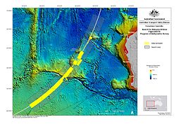
Towed Pinger Locator path & seafloor sonar survey location:
- Australian Transport Safety Bureau – MH370 – Definition of Underwater Search Areas
- Figure 12: Ocean Shield TPL search coverage 04-14 April (pg. 13; source: Phoenix International)
- Figure 14: Ocean Shield AUV coverage 14 April-28 May 2014 (pg. 15; source: Royal Australian Navy)
Background:
- Bathymetric color relief derived from the ETOPO1 bedrock DEM from NOAA (public domain)
- Australia & island outlines: Natural Earth 1:10m Physical Vectors (public domain)
Relevante Bilder


Relevante Artikel
Malaysia-Airlines-Flug 370Der Malaysia-Airlines-Flug 370 war ein internationaler Linienflug von Kuala Lumpur nach Peking, bei dem eine Boeing 777 der Malaysia Airlines am 8. März 2014 aus der Überwachung der Flugverkehrskontrolle des Flughafens von Kuala Lumpur verschwand und plötzlich die Richtung änderte. Bislang wurde keine offizielle Ursache für das Verschwinden des Fluges MH370 genannt. Der Vorfall wird daher als eines der größten Rätsel der Luftfahrtgeschichte bezeichnet. Die aus Radar- und Satellitendaten gewonnenen Erkenntnisse legen allerdings − zumindest für die vom Radar erfasste Flugphase und die aus Satellitendaten abgeleitete anschließende Wende nach Süden – eine vorsätzliche Handlung durch einen Piloten oder durch Flugzeugentführer nahe. Da das Hauptwrack bisher nicht lokalisiert werden konnte, gilt Flug MH370 bis heute als vermisst. .. weiterlesen
