Land loss in coastal Louisiana since 1932 NOAA2013
Autor/Urheber:
NOAA
Shortlink:
Quelle:
Größe:
776 x 1006 Pixel (295686 Bytes)
Beschreibung:
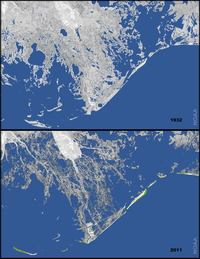
Every year, 25-35 square miles of land off the coast of Louisiana—an area larger than Manhattan–disappears into the water due to a combination of subsidence (soil settling) and global sea level rise. The maps at right show how much land has been lost to the Gulf of Mexico in the past 80 year. The second image shows the state of the coast in 1932. The image combines the 2011 satellite image with a U.S. Geological Survey map in which land areas that were present in 1932 are light gray. Since the 1930s, (source : NOAA ; Underwater: Land loss in coastal Louisiana since 1932 (click under the picture to see the two maps), on line 2013-04-04
Lizenz:
Public domain
Credit:
NOAA : Underwater: Land loss in coastal Louisiana since 1932 (click under the picture to see the two maps), on line 2013-04-04
Bild teilen:


Relevante Bilder


Relevante Artikel
Mississippi River DeltaDas Mississippi River Delta ist eine Land- und Wasserfläche, die sich seit dem Holozän bildet, weil durch den Mississippi River transportierte Schwebestoffe sich vor der Mündung des Flusses ablagern. In den letzten fünftausend Jahren hat sich so die Küste Louisianas um 25 bis 80 Kilometer in den Golf von Mexiko vorgeschoben. Das Mississippi-Delta ist der südlichste Teil der Lower Mississippi Delta Region, die rund 1200 Kilometer weiter flussaufwärts im südlichen Illinois beginnt. Das Delta ist bis zu der Ortschaft Venice über eine befestigte Straße (LA-23) erschlossen. .. weiterlesen