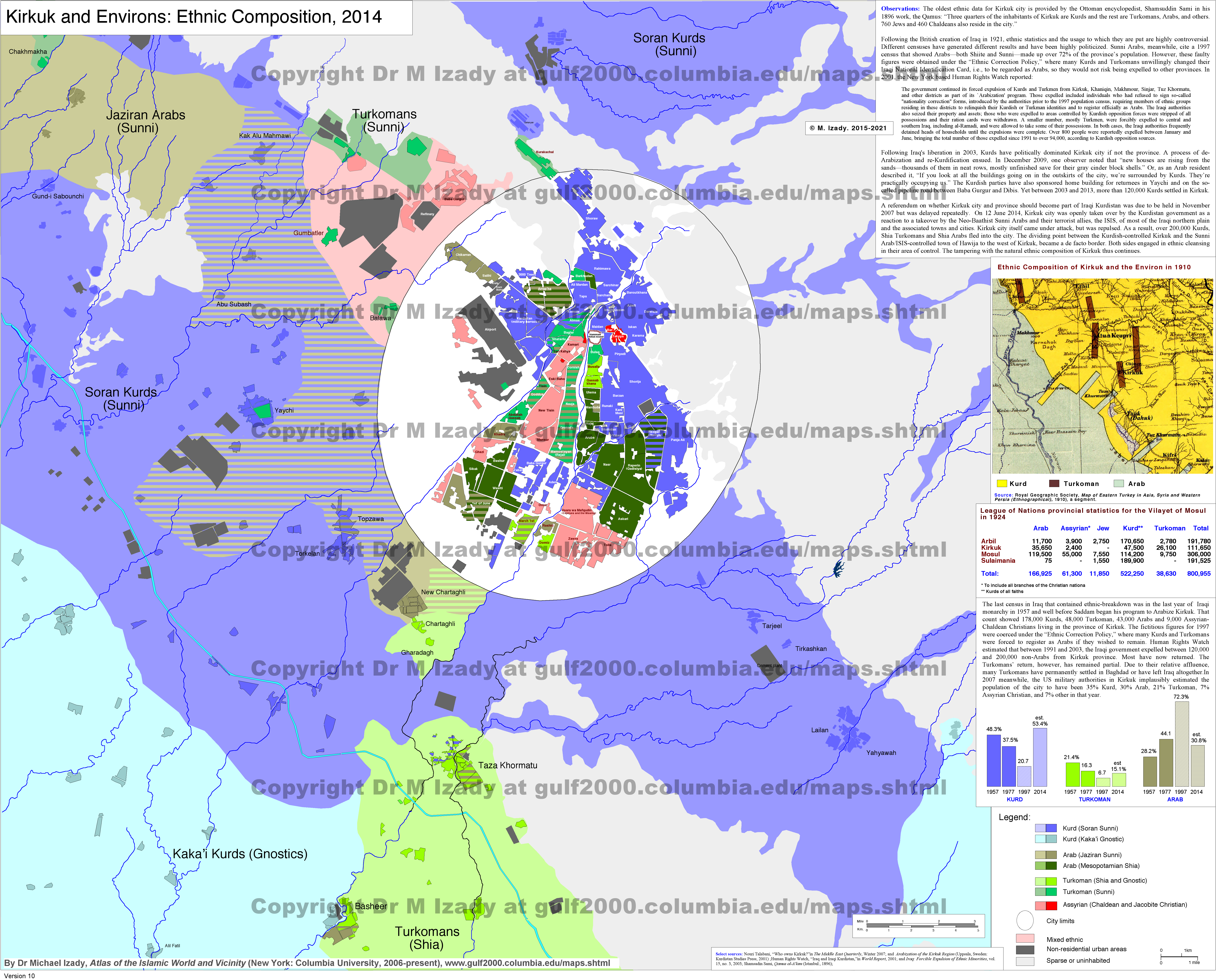
Kirkuk Demographical Map 2014

A combination of sources was used:
Primary
Other
- Michael Izady 2 - University of Columbia
- Endangered Community: The Turkoman Identity in Iraq, Oğuzlu, H. Tarık, 2004, Carfax Publishing 1
- Cecil John Edmonds, "The Kurds of Iraq," Middle East Journal, Winter 1957, p. 59; idem, "The Kurds and Revolution in Iraq," Middle East Journal, Winter 1959, p. 10.
- The Report of Mr. Young, Young, Wikie, Mosul, 5th April 1910, The National Archives, UK, File No: FO 371/1008
- The Turkmen Reality in Iraq, Hürmüzlü, Erşat, 2009, ISBN: 9789756849118
- The Demographic Situation of Kirkuk and Iraqi Constitution, Hürmüzlü, Erşat. 1
- ORSAM
This file (map · collage · logo · graphic · etc.) is a part of the Project: You are free to reuse this work for any purpose as long as you credit BRKY24 and follow the terms of the license listed below. See also: Turkey Project Page. |
This work was composed by BRKY24. You are free to reuse this work for any purpose as long as you credit BRKY24 and follow the terms of the license listed below. See also: BRKY24 Profile Page. |


Relevante Bilder


Relevante Artikel
KirkukKirkuk ist eine Universitätsstadt im Norden des Irak und die sechstgrößte Stadt des Landes. Sie ist das Zentrum der irakischen Erdölindustrie. Die Stadt Kirkuk liegt in einer Ebene mit einem Hügel. Der Hügel enthält mit der Zitadelle den ältesten Teil der Stadt. Kirkuk wird durch den Fluss Hassa und die Zitadelle in drei Teile geteilt. Seit der Destabilisierung des Landes 2003 gehört die Stadt zu den umstrittenen Gebieten des Nordiraks. .. weiterlesen