Kakhovka Reservoir Drys Up (MODIS)
Kakhovka Reservoir was created in 1956 by construction of a 30-meter (98-foot)-high dam across the Dnipro River. The Nova Kakhovka Dam, measuring 2 kilometers (1.2 miles) in length, powered a hydroelectric plant and held water in a massive reservoir that was used for agriculture, drinking water, and provided cooling to the Zaporizhzhia nuclear plant.
When the Kakhovka Dam was breached on June 6, 2023, water from the adjacent reservoir surged into the Dnipro River toward the city of Kherson and the Black Sea, causing severe flooding downstream. Floodwaters began to recede after a few weeks, but a slower-moving water problem unfolded as the reservoir dried up.
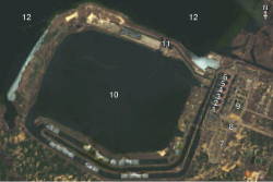
Agriculture has been seriously damaged as the reservoir no longer provides water to irrigation canals. Concern also exists about the nuclear reactors, although the facility has a large cooling pond that was separate from the reservoir. So far, efforts to keep the cooling pond filled by pumping water into it from an inlet have been successful.
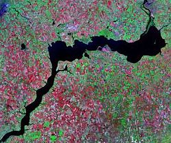
On August 8, 2023, the Moderate Resolution Imaging Spectroradiometer (MODIS) on NASA’s Terra satellite acquired a true-color image of the Dnipro River and the mud-colored remnants of the Kakhovka Reservoir. Clicking on the dates below the image will allow an easy comparison between the August 8, 2023, image and one acquired of the same area by MODIS on Terra on July 3, 2022, when the Kakhovka Reservoir was full and functional.
Nova Kakhovka, the town where the Dam was built, sits at the western-most edge of the former reservoir. The Dnipro passes Nova Kakhovka then flows into the Black Sea. The town of Zaporizhzhia and the nearby nuclear reactor are located on the Dnipro River just north of the eastern edge of the former reservoir.Relevante Bilder


Relevante Artikel
Zerstörung des Kachowka-StaudammsDie Zerstörung der Kachowka-Stauanlage ereignete sich am 6. Juni 2023 durch eine Explosion im Zuge der russischen Invasion in der Ukraine. Die Stauanlage lag am Fluss Dnipro und bildete den Kachowkaer Stausee im Unterlauf des Flusses, der hier im Wesentlichen nach Südwest fließt. Durch die Zerstörung der Wehranlage kam es zu großflächigen Überschwemmungen flussabwärts. Zum Zeitpunkt seiner Zerstörung befand sich die Stauanlage – wie auch das linke Ufer – unter russischer Kontrolle; der Pegelstand im regulär 18,2 Milliarden Kubikmeter Wasser fassenden Stausee lag zum Zeitpunkt der Zerstörung nahe seinem historischen Höchststand und 80 cm über dem normalen maximalen Pegel von 16 m. Russland und die Ukraine bezichtigten sich gegenseitig, für die Explosion verantwortlich zu sein, die den Dammbruch und die folgenden Überflutungen bewirkte. Nach wenigen Wochen wies die Fakten- und Indizienlage auf eine Verantwortung der russischen Seite hin. .. weiterlesen
