Hurricane ernesto 20060827
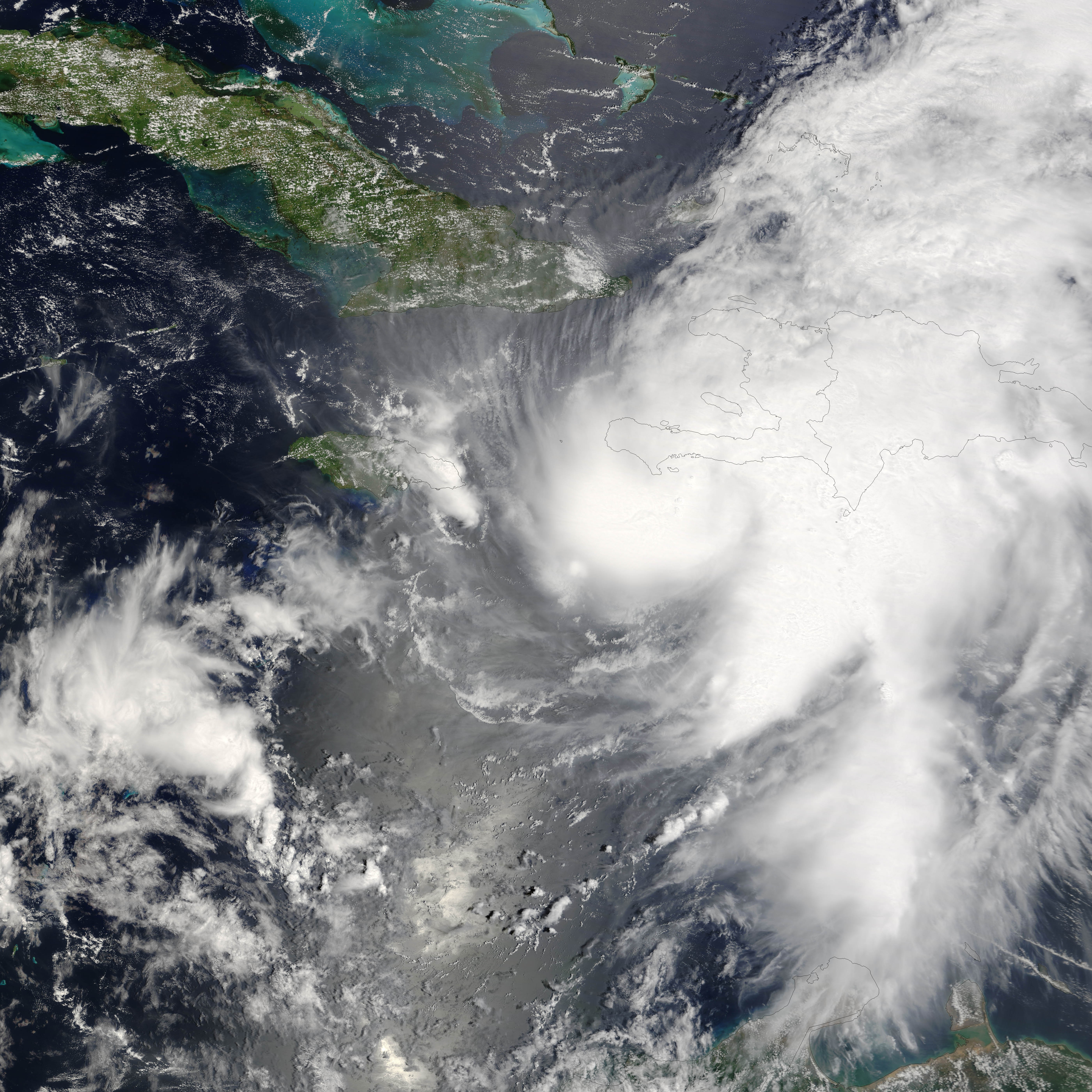
Hurricane Ernesto formed in the eastern Caribbean Sea on August 24, 2006. Within a day, it had become organized enough to be classified as a tropical storm and get named as the fifth storm of the 2006 Atlantic Season, Tropical Storm Ernesto. Ernesto built in power gradually as it moves westward and slightly north through the Caribbean Sea, just reaching hurricane strength as it neared Hispaniola (The island on which the nations of Haiti and Dominican Republic are located.) on August 27. This made it the first storm of the 2006 Atlantic season to reach hurricane strength. However, the interactions of the storm with land robbed Ernesto of enough power to sink it back to storm status again, where it is anticipated it will remain until at least after it crosses Cuba, forecast to have happened on August 28. If predictions made on August 28 hold true, the storm will travel most of the length of Cuba, then cross the Straits of Florida, possibly regaining enough power to become a hurricane again before coming ashore again in southern Florida.
This photo-like image was acquired by the Moderate Resolution Imaging Spectroradiometer (MODIS) on the Terra satellite on August 27 2006, at 11:50 a.m. local time (15:50 UTC). Hurricane Ernesto at the time of this image was a well-developed storm system, but its interactions with Hispaniola had started to distort the hurricane enough to rob it of a well-defined eye. According to the University of Hawaii’s Tropical Storm information center, Ernesto had sustained peak winds of around 110 kilometers per hour (65 miles per hour) at the time Aqua MODIS acquired these data.
The high-resolution image provided above is provided at the full MODIS spatial resolution (level of detail) of 250 meters per pixel. The MODIS Rapid Response System provides this image at additional resolutions.| Diese Datei ist gemeinfrei (public domain), da sie von der NASA erstellt worden ist. Die NASA-Urheberrechtsrichtlinie besagt, dass „NASA-Material nicht durch Urheberrecht geschützt ist, wenn es nicht anders angegeben ist“. (NASA-Urheberrechtsrichtlinie-Seite oder JPL Image Use Policy). |
|
|
 |
Warnung:
|


Relevante Bilder


Relevante Artikel
Atlantische Hurrikansaison 2006Die Atlantische Hurrikansaison 2006 begann offiziell am 1. Juni und endete am 30. November. Innerhalb dieser Periode bilden sich die meisten Tropischen Stürme, da nur zu dieser Zeit geeignete Bedingungen, wie etwa ein warmer Ozean, feuchte Luft und wenig Windscherung, existieren, um die Bildung von Tropischen Wirbelstürmen zu ermöglichen. Während der atlantischen Hurrikansaison 2006 gab es deutlich weniger Wirbelstürme, als zunächst am Beginn des Jahres prognostiziert wurde. Es gab keinen Hurrikan der Stärke 4 oder 5, insgesamt fünf Stürme, welche die Stärke eines Hurrikans erreichten, davon zwei Starke, und drei Stürme erreichten das Festland. Die höchste am Festland gemessene Windgeschwindigkeit betrug 72 km/h. Im Oktober und November 2006 bildete sich kein Wirbelsturm mehr. Damit war es eine Durchschnittssaison. .. weiterlesen