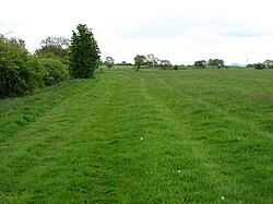
Hadrian's Wall National Trail near Whittle Dene Reservoirs - geograph.org.uk - 1027783
(c) Oliver Dixon, CC BY-SA 2.0
Autor/Urheber:
Shortlink:
Quelle:
Größe:
640 x 480 Pixel (123695 Bytes)
Beschreibung:
Hadrian's Wall National Trail near Whittle Dene Reservoirs, near to Harlow Hill, Northumberland, Great Britain.
Erosion is a constant problem on the very popular Hadrians Wall National Trail which runs 135 km from Bowness-on-Solway to Wallsend.
Kommentar zur Lizenz:
Creative Commons Attribution Share-alike license 2.0
Lizenz:
Credit:
Relevante Bilder

(c) Oliver Dixon, CC BY-SA 2.0

(c) Oliver Dixon, CC BY-SA 2.0

(c) Oliver Dixon, CC BY-SA 2.0

(c) Oliver Dixon, CC BY-SA 2.0

(c) Oliver Dixon, CC BY-SA 2.0

(c) Oliver Dixon, CC BY-SA 2.0

(c) Anthony Parkes, CC BY-SA 2.0

(c) Mike Quinn, CC BY-SA 2.0

(c) David Purchase, CC BY-SA 2.0

(c) David Purchase, CC BY-SA 2.0

(c) Mike Quinn, CC BY-SA 2.0

(c) David Purchase, CC BY-SA 2.0

(c) Mike Quinn, CC BY-SA 2.0

(c) David Purchase, CC BY-SA 2.0

(c) Mike Quinn, CC BY-SA 2.0

(c) David Purchase, CC BY-SA 2.0

(c) Mike Quinn, CC BY-SA 2.0

(c) Mike Quinn, CC BY-SA 2.0

(c) David Purchase, CC BY-SA 2.0

(c) Les Hull, CC BY-SA 2.0

(c) Mike Quinn, CC BY-SA 2.0

(c) Mike Quinn, CC BY-SA 2.0

(c) Alan Fearon, CC BY-SA 2.0

(c) Mike Quinn, CC BY-SA 2.0

(c) Ian S, CC BY-SA 2.0

(c) Mike Quinn, CC BY-SA 2.0

(c) Mike Quinn, CC BY-SA 2.0

(c) Ian S, CC BY-SA 2.0

(c) Mike Quinn, CC BY-SA 2.0

(c) Mike Quinn, CC BY-SA 2.0

(c) Mike Quinn, CC BY-SA 2.0

(c) Mike Quinn, CC BY-SA 2.0

(c) Mike Quinn, CC BY-SA 2.0

(c) Richard Young, CC BY-SA 2.0

(c) Dave Dunford, CC BY-SA 2.0

(c) Ian S, CC BY-SA 2.0

(c) Mike Quinn, CC BY-SA 2.0

(c) Ian S, CC BY-SA 2.0

(c) Andrew Smith, CC BY-SA 2.0

(c) Duncan Grey, CC BY-SA 2.0

(c) Les Hull, CC BY-SA 2.0

(c) Mike Quinn, CC BY-SA 2.0
Relevante Artikel
Meilenkastelle und Wachtürme am HadrianswallDer Hadrianswall war eine Grenzbefestigungsanlage im Norden der britischen Insel, die 122 n. Chr. auf Anordnung Kaiser Hadrians errichtet wurde. Er sicherte die nördlichste Grenze (Limes) des römischen Reiches. Der Wall ist die am umfangreichsten erforschte Befestigungsanlage am Limes Britannicus. .. weiterlesen
