Glacial lakes, Bhutan
According to a joint press release issued by NASA and the U.S. Geological Survey, the great majority of the world’s glaciers appear to be declining at rates equal to or greater than long-established trends. This image from the ASTER (Advanced Spaceborne Thermal Emission and Reflection Radiometer) instrument aboard NASA’s Terra satellite shows the termini of the glaciers in the Bhutan-Himalaya. Glacial lakes have been rapidly forming on the surface of the debris-covered glaciers in this region during the last few decades.
| Diese Datei ist gemeinfrei (public domain), da sie von der NASA erstellt worden ist. Die NASA-Urheberrechtsrichtlinie besagt, dass „NASA-Material nicht durch Urheberrecht geschützt ist, wenn es nicht anders angegeben ist“. (NASA-Urheberrechtsrichtlinie-Seite oder JPL Image Use Policy). |  | |
 |
Warnung:
|
Relevante Bilder


Relevante Artikel
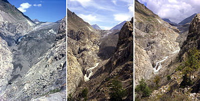
Gletscherschwund seit 1850Seit Mitte des 19. Jahrhunderts ist nahezu weltweit ein deutlicher Rückgang der Gletscher zu beobachten. Dieser Vorgang wird Gletscherschwund oder Gletscherschmelze genannt. Gemeint ist damit ein längerfristiger Massenverlust der Gletscher und nicht die in Gebirgen und Hochlagen alljährlich im Frühling einsetzende Schneeschmelze, auch nicht grundsätzlich das Schmelzen im Zehrgebiet, das bei Gletschern, die sich im Gleichgewicht mit dem Klima befinden, im gleichen Maße wie der Massengewinn im Nährgebiet auftritt. Eine wesentliche Messgröße zur Beurteilung des Gletscherschwunds ist die von Glaziologen erhobene Massenbilanz. Das Verhalten des Gletschers wird durch die Gletscherdynamik beschrieben. Der Gletscherschwund steht insbesondere in Zusammenhang mit der vom Menschen verursachten globalen Erwärmung. .. weiterlesen
