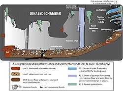
Geological map and cross-section of the Rising Star cave system
Autor/Urheber:
Paul H. G. M. Dirks et al
Attribution:
Das Bild ist mit 'Attribution Required' markiert, aber es wurden keine Informationen über die Attribution bereitgestellt. Vermutlich wurde bei Verwendung des MediaWiki-Templates für die CC-BY Lizenzen der Parameter für die Attribution weggelassen. Autoren und Urheber finden für die korrekte Verwendung der Templates hier ein Beispiel.
Shortlink:
Quelle:
Größe:
4184 x 4198 Pixel (976505 Bytes)
Beschreibung:
Geological map and cross-section of the Rising Star cave system.
(A) Geological Map showing the distribution of chert-free dolomite and fracture systems controlling the cave. Inset shows the location of the Cradle of Humankind in southern Africa; (B) Northeast-Southwest, schematic cross section through the cave system, relative to several chert marker horizons; (C) Detailed map of the Dinaledi Chamber showing the orientation of the floor and the position of the excavation and sampling sites.
Lizenz:
Relevante Bilder
Relevante Artikel
Rising-Star-HöhleDie Rising-Star-Höhle ist eine südafrikanische Fundstätte von Fossilien im Gebiet des UNESCO-Welterbes Cradle of Humankind, unweit von Krugersdorp. Im September 2013 wurde in dem Höhlensystem eine Passage entdeckt, die „zu einer spektakulären Fundstelle von Homininenknochen“ führt. .. weiterlesen


