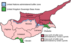
Cyprus GHI Solar-resource-map GlobalSolarAtlas World-Bank-Esmap-Solargis
© The World Bank, Source: Global Solar Atlas 2.0, Solar resource data: Solargis, CC BY 4.0
Autor/Urheber:
Solargis
Shortlink:
Quelle:
Größe:
1842 x 1603 Pixel (1353222 Bytes)
Beschreibung:
Solar resource: GLOBAL HORIZONTAL IRRADIATION (GHI) - this map provides a summary of the estimated solar energy available for power generation and other energy applications. It represents the long-term average of daily/yearly totals of global horizontal irradiation (GHI). The underlying solar resource database is calculated by the Solargis model from atmospheric and satellite data with 15- or 30-minute time step. The effects of terrain are considered at nominal spatial resolution of 250 m. GHI is the most important parameter for energy yield calculation and performance assessment of flat-plate photovoltaic (PV) technologies. Further details available at: https://globalsolaratlas.info.
Lizenz:
Relevante Bilder
Relevante Artikel
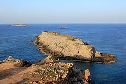
KarpasDer Karpas, auch Karpass, ist eine knapp 900 km² umfassende und mindestens 80 km lange Halbinsel im Nordosten der Mittelmeerinsel Zypern. Sie bildet den östlichsten Teil des Kyrenia-Gebirges. Seine östliche Spitze bildet das Kap Apostolos Andreas, dem die unbewohnten Kleides-Inseln (‚Schlüssel‘) vorgelagert sind. .. weiterlesen


