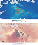
Chlorophyll concentration off the Galapagos archipelago during El Niño and La Niña
Autor/Urheber:
GSFC Ocean Color team and GeoEye.
Shortlink:
Quelle:
Größe:
468 x 535 Pixel (157869 Bytes)
Beschreibung:
El Niño and La Niña, large-scale shifts in winds and currents in the equatorial Pacific, have dramatic effects on the ecosystems of the Galapagos. These satellite maps show chlorophyll concentration (which corresponds with the abundance of microscopic ocean plants, called phytoplankton) during El Niño (top) and La Niña (lower). Blue represents low concentrations, while yellow, orange and red indicate high concentrations. Currents that normally fertilize the phytoplankton reverse during El Niño, resulting in barren oceans. These same currents are strengthened by La Niña resulting in an explosion of ocean life.
Lizenz:
Public domain
Credit:
Relevante Bilder
Relevante Artikel
GalapagosinselnDie Galapagosinseln sind ein Archipel im östlichen Pazifischen Ozean. Sie liegen am Äquator ca. 1000 km westlich der ecuadorianischen Küste in Südamerika und gehören zu Ecuador. Sie bilden die gleichnamige Provinz Galápagos mit der Hauptstadt Puerto Baquerizo Moreno auf San Cristóbal. Das Wort Galápago bezieht sich auf den Schildkrötenpanzer, der bei einigen Arten der Galapagos-Riesenschildkröten im Nackenbereich wie ein Sattel aufgewölbt ist. .. weiterlesen


