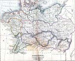
Central Europe in the early 14th century.
Autor/Urheber:
Dr. Karl von Spruner
Shortlink:
Quelle:
Größe:
700 x 538 Pixel (151511 Bytes)
Beschreibung:
Map shows Central Europe in the early 14th century. Poland is shown after the loss of Pomerelia (Teutonic takeover of Gdańsk) and Lubusz Land, but before the loss of Silesia.
Lizenz:
Public domain
Credit:
Historisch Geographischer Handatlas, zweite Abtheilung, zweite Auflage, Justus Pertes
Relevante Bilder
Relevante Artikel
PommerellenPommerellen, auch Weichselpommern oder Ostpommern im Polnischen Sinne, einschließlich Danziger Pommern, ist eine historische Landschaft an der Ostseeküste in der heutigen polnischen Woiwodschaft Pommern. .. weiterlesen


