Battle of Beersheba map
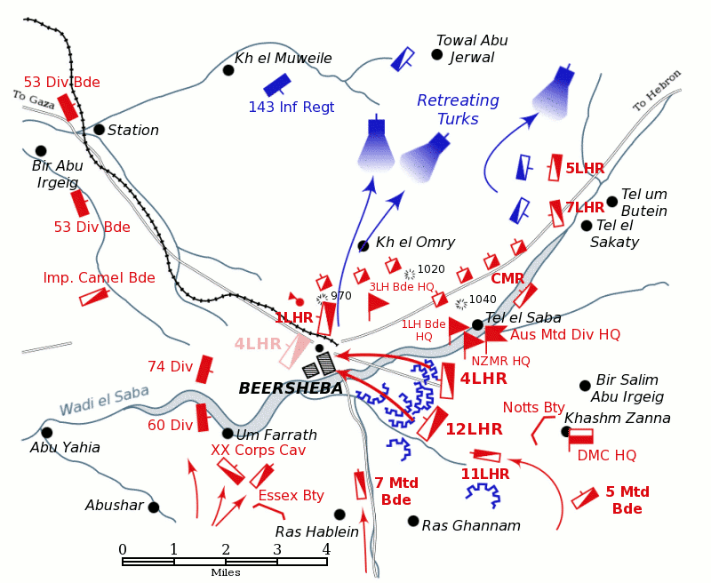
Positions of forces at dusk on October 31, 1917, during the Battle of Beersheba at the time of the charge of the 4th Light Horse Brigade.
British forces are shown in red, Turkish forces are shown in blue. The position reached by the regiments of the 4th Light Horse Brigade after the attack is shown in pale red. Note: there is no evidence that the 4th Light Horse Regiment crossed the Wadi Saba during their attack, nor that the 60th Division attacked south of the Wadi Saba. The Australian Mounted Division headquarters is shown where the Anzac Mounted Division headquarters moved to, after the capture of Tel el Saba. Neither the Gullett map nor Bou's map locates the headquarters of Anzac Mounted Division, Australian Mounted Division and Desert Mounted Corps at Kashim Zanna despite numemrous sources placing them there. [Preston 1921 pp. 25–6, Powles 1922 pp. 136–7, Hill 1978 p. 126] See the Battle of Beersheba article for more information.


Relevante Bilder


Relevante Artikel
Schlacht von BeerschebaDie Schlacht von Beerscheba wurde am 31. Oktober 1917 zwischen dem Vereinigten Königreich und dem Osmanischen Reich ausgetragen. .. weiterlesen