Andorra topographic map-de
Autor/Urheber:
Attribution:
Das Bild ist mit 'Attribution Required' markiert, aber es wurden keine Informationen über die Attribution bereitgestellt. Vermutlich wurde bei Verwendung des MediaWiki-Templates für die CC-BY Lizenzen der Parameter für die Attribution weggelassen. Autoren und Urheber finden für die korrekte Verwendung der Templates hier ein Beispiel.
Shortlink:
Quelle:
Größe:
1625 x 1300 Pixel (1653595 Bytes)
Beschreibung:
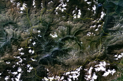
Topographische Karte von Andorra, deutsche Version
Kommentar zur Lizenz:
GFDL / Attribution and Share-Alike required
Lizenz:
Credit:
Own work;
Topographic data from the NASA Shuttle Radar Topography Mission (SRTM3 v.2) (public domain) edited with 3DEM and dlgv32 Pro and vectorized with Inkscape; UTM projection; WGS84 datum; shaded relief (composite image of N-W, W and N lightning positions);
Reference used for the additional data:
* Topographic maps available on the site of the Ministeri d'Urbanisme i Ordenament Territorial of Andorra;
* Géoportail France;
Approximate scale of topographic data: 1:400,000 (accuracy: about 100 m);
Note: The shaded relief is a raster image embedded in the SVG file.
Relevante Bilder



(c) Football.ua, CC BY-SA 3.0

(c) Diego Delso, CC BY-SA 3.0

(c) Diego Delso, CC BY-SA 4.0



(c) Diego Delso, CC BY-SA 3.0






(c) Joan M. Borràs (ebrenc), CC BY-SA 2.5





Relevante Artikel
AndorraAndorra ist ein in den östlichen Pyrenäen zwischen Spanien und Frankreich gelegener demokratischer Staat in Form einer parlamentarischen Monarchie. .. weiterlesen
