Aldwych in 1900 (station location)
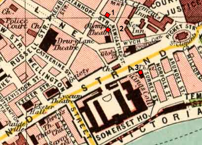
Map of Aldwych area of London circa 1900, annotated with the planned and final locations of Aldwych underground station:
1. Planned location; corner of Stanhope & Holles Street (Holles Street not shown)
2. Planned location; junction of Kingsway and Aldwych (both roads were constructed later)
see below
Map taken from Plate 7 of "The Pocket Atlas & Guide to London" by John Bartholomew and Son.


Relevante Bilder


.svg)

.jpg)


.png?uselang=de)
Relevante Artikel
Aldwych (London Underground)Aldwych [ˈɔːldwɪtʃ] ist eine geschlossene Station der London Underground. Sie liegt im Londoner Stadtbezirk City of Westminster und war die Endstation einer kurzen Stichstrecke der Piccadilly Line, die an der Station Holborn in Richtung Süden abzweigte. Diese Strecke war ein Überbleibsel aus der Zusammenlegung zweier verschiedener U-Bahn-Projekte. Das nicht mehr genutzte Stationsgebäude befindet sich nahe der Kreuzung von Strand und Surrey Street. .. weiterlesen