2 Cassis
Autor/Urheber:
Spiridon Manoliu
Shortlink:
Quelle:
Größe:
882 x 716 Pixel (752292 Bytes)
Beschreibung:
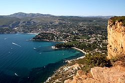
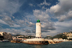
Cassis harbour and cap canaille (= Dirty Cape), near Cassis, Department of Bouches du Rhone, France. The portion of the coast wich contain the "Cap Canaille" is in the PACA region - by BRGM, IFREMER, and the french "Earthquake Master plan" - the site most at risk of "unstable slopes withmobilizationbrutal field" when significant seismic. The collapse of the terrestrial and submarine such a structure would generate a Tsunami and a wave background can resuspend enormous amount of fine particles from the underwater industrial discharge close (Fosse Cassidaigne) of plant Pechiney / Alcan Rio Tinto. in french, this sort of area is called "tsunamogéniques"
Lizenz:
Public domain
Credit:
Spiridon Manoliu
Relevante Bilder
Relevante Artikel
CassisCassis [kaˈsi] ist eine französische Stadtgemeinde mit 6720 Einwohnern im Département Bouches-du-Rhône (13) in der Region Provence-Alpes-Côte d’Azur. Sie gehört zum Arrondissement Marseille und zum Kanton La Ciotat. Cassis ist ein Hauptakteur in der Entwicklung des Nationalparks Calanques. .. weiterlesen


