Ystradfellte
| Ystradfellte walisisch Ystradfellte | |||
|---|---|---|---|
 (c) George Tod, CC BY-SA 2.0 | |||
| Koordinaten | 51° 49′ N, 3° 33′ W | ||
| OS National Grid | SN 93009 13461 | ||
| |||
| Traditionelle Grafschaft | Brecknockshire | ||
| Einwohner | 556 (Stand: 2011)[1] | ||
| Fläche | 82,784.2 km² (31,96 mi²) [1] | ||
| Bevölkerungsdichte: | 7 Einw. je km² | ||
| Verwaltung | |||
| Post town | ABERDARE | ||
| Postleitzahlenabschnitt | CF44 | ||
| Landesteil | Wales | ||
| Preserved County | Powys | ||
| Unitary authority | Powys | ||
| Community | Ystradfellte | ||
| ONS-Code | W04000355 | ||
| Britisches Parlament | Brecon and Radnorshire | ||
| Walisisches Parlament | Brecon and Radnorshire | ||
Ystradfellte ist ein Dorf und eine Community in der walisischen Principal Area Powys.
Geographie
Ystradfellte liegt in den Brecon Beacons nordwestlich von Merthyr Tydfil in einer bergigen Region mit zahllosen Bächen und Flüssen, das Teil des Brecon-Beacons-Nationalparks ist.[2] Zu den nennenswertesten dieser Wasserläufe gehören der River Neath, der Afon Pyrddin, der Afon Hepste und der Afon Mellte, der durch Ystradfellte selbst läuft und nördlich des Dorfes auch das sogenannte Ystradfellte Reservoir durchquert. Mehrere dieser Flussläufe beinhalten zudem Wasserfälle.[1] Des Weiteren gibt es um Ystradfellte einige Höhlen.[3] Abgesehen von Einzelsiedlungen sind das Dorf Ystradfellte in der Mitte der Community und das Dorf Pontneddfechan ganz im Süden die einzigen Siedlungen.[2]
 (c) Alan Bowring, CC BY-SA 2.0
Eingang zu Höhle Porth yr Ogof

Eingang zur selben Höhle von der anderen Seite
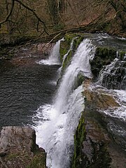
Der Wasserfall Sgwd y Pannwr
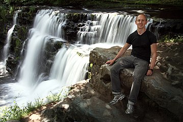
Weiterer Wasserfall mit Tourist
 (c) Hywel Williams, CC BY-SA 2.0
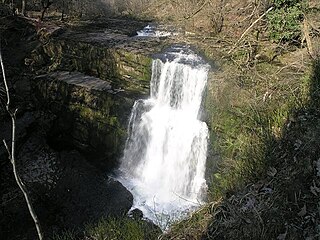
Der Wasserfall Sgŵd Clun-gwyn

Geschichte
Seit dem Mittelalter steht in Ystradfellte eine Kirche, die aber vermutlich im 16. Jahrhundert komplett neu errichtet wurde.[3] Anfang der 1870er-Jahre gab es in Ystradfellte einige Mühlen sowie Backstein- und Schamottenfabriken.[4] Früher gehörte Ystradfellte zu Brecknockshire, seit 1974 ist es aber Teil von Powys. Heutzutage ist vor allem der Tourismus ein wichtiger Wirtschaftszweig.[3]
Einwohnerzahlen
| Jahr | 1801 | 1811 | 1821 | 1831 | 1841 | 1851 | 1861 | 1871 | 1881 | 1891 | 1901 | 1911 | 1921 | 1931 | 1941 | 1951 | 1961[5] | 1971 | 1981 | 1991 | 2001 | 2011 |
|---|---|---|---|---|---|---|---|---|---|---|---|---|---|---|---|---|---|---|---|---|---|---|
| Einwohner | 669 | 710 | 760 | 747 | 682 | 711 | 668[4] | 719 | 587 | 594 | 549 | 627 | 613 | 650 | ? | 616 | 638 | ? | ? | ? | ? | 556[1] |

Verkehr
Ystradfellte ist durchzogen von kleinen Nebenstraßen. Als einzige größere Straße verläuft die A4059 road auf der Ostgrenze der Community. Im Süden tangiert die Community zudem die überregionale A465 road.[1][2]
Infrastruktur
In Ystradfellte gibt es ein temporäres Postbüro.[6] Im Hauptdorf gibt es zudem eine Kirche.[7] Nördlich von Pontneddfechan gibt es einen Golfplatz.[1]
Bauwerke
Auf dem Gebiet der Community stehen insgesamt zwölf Bauwerke, die in die Statutory List of Buildings of Special Architectural or Historic Interest aufgenommen wurden. Zumeist sind dies Grade II buildings, lediglich die Church of St Mary in Ystradfellte ist ein Grade II* building.[7]
Weblinks
- Website des Ystradfellte Community Councils (englisch)
- Electricity Comes To Ystradfellte, September 1960 Video
- illustrierter Führer zu den Wasserfällen (englisch)
Einzelnachweise
- ↑ a b c d e f Ystradfellte Parish – Local Area Report. In: www.nomisweb.co.uk. University of Durham, abgerufen am 16. Mai 2021 (englisch).
- ↑ a b c Election Maps. Ordnance Survey, abgerufen am 16. Mai 2021 (englisch).
- ↑ a b c Ystradfellte in the Brecon Beacons Tour and Tourist Information Guide. Visit Brecon Beacons, 2007, abgerufen am 16. Mai 2021 (englisch).
- ↑ a b History of Ystradfellte, in Powys and Brecknockshire. In: A Vision Of Britain Through Time. University of Portsmouth, abgerufen am 16. Mai 2021 (englisch).
- ↑ Ystradfellte CP/AP through time | Population Statistics. In: A Vision Of Britain Through Time. University of Portsmouth, abgerufen am 16. Mai 2021 (englisch).
- ↑ Ystradfellte. Royal Mail, abgerufen am 16. Mai 2021 (englisch).
- ↑ a b Listed Buildings in Ystradfellte, Powys. British Listed Buildings, abgerufen am 16. Mai 2021 (englisch).
Auf dieser Seite verwendete Medien
(c) George Tod, CC BY-SA 2.0
Ystradfellte Village Looking down the hill from the west towards the New Inn and church.

Autor/Urheber: NordNordWest, Lizenz: CC BY-SA 3.0
Positionskarte von Wales, Vereinigtes Königreich

(c) Alan Bowring, CC BY-SA 2.0
Afon Mellte about to enter Porth yr Ogof Even in flood the waters of the Afon Mellte are easily swallowed by the limestone cavern known as Porth yr Ogof (literally 'gateway to the cave'). Popular with organised groups (in low water conditions),there have been fatalities here amonsgt those entering the cave unprepared. The shot was taken from just inside the entrance looking out.
(c) Robert Davies, CC BY-SA 2.0
St Mary's Church, Ystradfellte The Church building dates from the 16th Century but some parts are possibly from an earlier period.

Sgŵd y Pannwr, a waterfall on the Afon Mellte near Ystradfellte in the Brecon Beacons National Park . Photograph taken 17th April 2005.

(c) Hywel Williams, CC BY-SA 2.0
Sgŵd Clun-gwyn Sgŵd Isaf Clun-gwyn, or sometimes named Sgŵd Isaf Uchaf Clun-gwyn (Clun-gwyn's upper falls) is not in full flow when this picture was taken - in flood, the waterfall takes up the entire shelf with its majesty.
.jpg)
Autor/Urheber: Charlie Marshall from Bristol UK, United Kingdom, Lizenz: CC BY 2.0
Earlier today, sitting in front of one of the four waterfalls in a small area of South Wales