West-MacDonnell-Nationalpark
| West-MacDonnell-Nationalpark | ||
|---|---|---|
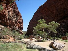
| Simpsons Gap | ||
| Lage: | Northern Territory, Australien | |
| Besonderheit: | Gebirgszug mit Schluchten | |
| Nächste Stadt: | 30 km von Alice Springs | |
| Fläche: | 2069 km² | |
| Gründung: | 1992 | |
| Blick entlang der West MacDonnell Ranges vom Larapinta Trail, nahe Glen Helen. | ||
Der West-MacDonnell-Nationalpark (engl. West MacDonnell National Park) umfasst ein 2069 km² großes Gebiet im Gebirgszug der MacDonnell Ranges im australischen Nordterritorium westlich der Stadt Alice Springs.
Er wurde 1992 gegründet, nachdem die Regierung des Northern Territory 170.000 ha Land von fünf wegen mehrfacher Abbruchlawinen aufgegebenen Rinderfarmen gekauft hatte.
Von Alice Springs aus ist der Nationalpark durch asphaltierte Straßen angebunden (Larapinta Drive und Namatjira Drive). Vom Uluṟu aus gibt es eine Piste, die nur mit Allradantrieb befahrbar ist.
Zu den touristischen Attraktionen dieses Nationalparks zählen:
- Larapinta-Trail: Teile des 223 km langen Fernwanderweges verlaufen durch den Nationalpark.
- Rungutjirpa (Simpson's Gap): Felsenschlucht aus rotem Sandstein; mit etwas Glück zeigen sich am frühen Morgen Felskängurus sowie einige seltene Vogelarten; am Ende der Schlucht permanente Wasserstelle. Nach Überlieferung der Arrernte-Aborigines waren ihre Vorfahren an diesem Ort Riesen.
- Udepata (Ellery Gorge) im Ellery Creek Big Hole: Enge Wasser führende Serpentinenschlucht mit Flusseukalypten.
- Ormiston Gorge: Schlucht mit 300 m hohen Wänden aus zwei übereinander liegenden Quarzschichten.
- Redback Gorge
- Glen Helen Gorge
Weblinks
Auf dieser Seite verwendete Medien
Autor/Urheber: Prince Roy, Lizenz: CC BY-SA 3.0
Simpsons Gap in the West MacDonnell Ranges
Autor/Urheber: Tentotwo, Lizenz: CC BY-SA 3.0
Relief location map of the Northern Territory, Australia Equidistant cylindrical projection, latitude of true scale 17.75° S (equivalent to equirectangular projection with N/S stretching 105 %). Geographic limits of the map:
- N: 10.6° S
- S: 26.5° S
- W: 127.5° E
- E: 139.5° E
View along the West MacDonnell Ranges from Counts Point on the Larapinta Trail. Mount Sonder, one of the higherst mountains in the Northern Territory, is in the background.
The flag of the Northern Territory (adopted on July 1, 1978 on the first day of self-government) was designed by the Australian artist Robert Ingpen, of Drysdale Victoria, after consultation with members of the community at the invitation of the Northern Territory government. The flag incorporates the three official territorial colours of black, white and ochre and is divided into two panels, black at the hoist side taking up one third the length of the flag, with the remaining two-thirds in ochre. The black panel displays the five white stars that form the constellation of the Southern Cross, using the Victorian configuration with stars having between five and eight points. The flag also features the official Northern Territory floral emblem on the ochre panel, a stylisation of the Sturt's Desert Rose, which uses seven petals encircling a seven-pointed black star of the federation in the centre. The seven petals symbolise the six Australian states plus the Northern Territory. The Northern Territory Flag was the first official flag that did not contain the Union Jack.


