Walgreen-Küste
| Walgreen-Küste | ||
|---|---|---|
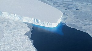
 Thwaites-Gletscher an der Walgreen-Küste | ||
| Lage | Marie-Byrd-Land, Westantarktika | |
| Gewässer | Amundsen-See | |
| Von | Kap Herlacher 73° 52′ 0″ S, 114° 12′ 0″ W | |
| Bis | Kap Waite 72° 42′ 0″ S, 103° 3′ 0″ W | |
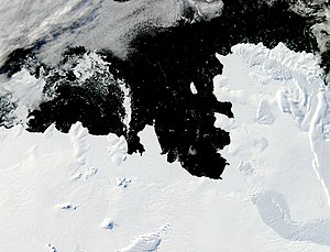
 Satellitenaufnahme der Walgreen-Küste | ||
Koordinaten: 76° S, 107° W
Die Walgreen-Küste ist ein Küstenabschnitt im Osten des westantarktischen Marie-Byrd-Lands. Er liegt zwischen dem Kap Herlacher und dem Kap Waite und grenzt damit direkt an die östlich gelegene Eights-Küste, die bereits zum Ellsworthland gerechnet wird. Im Westen schließt sich die Bakutis-Küste an.
Entdeckt wurde die Küste vom US-amerikanischen Polarforscher Richard Evelyn Byrd bei der United States Antarctic Service Expedition (1939–1941) im Februar 1940. Byrd benannte sie nach dem US-amerikanischen Unternehmer Charles Rudolph Walgreen (1873–1939), Gründer der Apothekenkette Walgreens und Sponsor der Forschungsreise. Der United States Geological Survey kartierte sie detailliert anhand eigener Vermessungen und Luftaufnahmen, die die United States Navy zwischen 1959 und 1966 angefertigt hatte.
Weblinks
- Walgreen Coast. In: Geographic Names Information System. United States Geological Survey, United States Department of the Interior, archiviert vom (englisch).
- Walgreen Coast auf geographic.org (englisch)
Auf dieser Seite verwendete Medien
Autor/Urheber: Alexrk2, Lizenz: CC BY-SA 3.0
Physische Positionskarte Antarktis, Mittabstandstreue Azimutalprojektion
Pine Island Bay is tucked into a corner of the West Antarctic’s Walgreen Coast. The bay, which opens to the Amundsen Sea, is typically filled with sea ice at this time of year, but when this image was taken, the bay was largely ice-free. Acquired at the end of the Antarctic summer, the image is illuminated by fairly low-angled sunlight, which highlights raised and textured areas, including ice-covered peninsulas and the corrugated surface of iceberg B-22A. B-22A broke from the Mertz Glacier Tongue several thousand miles to the west; it may be grounded on a submarine shoal. Northwest of the iceberg is a combination of sea ice and grounded icebergs. This sea ice/iceberg feature has been larger in recent Antarctic summers than it appears in this image. The coast of Antarctica not only has sea ice that comes and goes from year to year, but also longer-lasting ice shelves (thick slabs of ice attached to the coastline that partially float on the ocean surface). Among the ice shelves on the Walgreen Coast is Dotson Ice Shelf. Although most of the surface appears smooth, several long cracks appear to trace the leading edge of the shelf, hinting that the margin may calve some long, narrow icebergs in coming summers. The presence or absence of sea ice affects both ocean surface waters and ice shelves. Thanks to its light colour, sea ice reflects much of the Sun’s energy back into space, keeping underlying ocean waters cool. Without a cover of sea ice, the surface waters of the ocean warm. The exposure to sunlight also makes it possible for phytoplankton to bloom. West of the line of grounded icebergs, the ice floating in the Amundsen Sea takes on a greenish colour; this may be due to phytoplankton or algae. When it comes to ice shelves, a sea-ice cap on the ocean surface dampens wave energy that might otherwise trigger ice-shelf retreat.


