Upembasee
| Upembasee | ||
|---|---|---|
 | ||
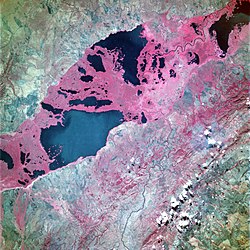
| (NASA 1993) | ||
| Geographische Lage | Provinz Haut-Lomami, | |
| Abfluss | → Lualaba | |
| Daten | ||
| Koordinaten | 8° 38′ S, 26° 23′ O | |
| Fläche | 530 km² | |
| Länge | 70 km | |
| Maximale Tiefe | 3,2 m | |
Der Upembasee ist ein See in der Demokratischen Republik Kongo.
Beschreibung
Er ist mit 530 km² der größte See im Bukama-Gebiet der Provinz Haut-Lomami. Er erstreckt sich über 70 km Länge, ist aber nur bis zu 3,2 m tief. Von März bis Juni ist der Wasserspiegel hoch, von Oktober bis Januar ist er niedrig.
Schutzgebiete
Der See ist Teil des Nationalparks Upemba und liegt in der moorigen Niederung, die durch den Lualaba gebildet wird, den eigentlichen Quellfluss des Kongo. In der Kamalondo-Depression gibt es neben dem Upembasee noch etwa 50 andere, als nächstgrößeren den Kisalesee.
Das Algenwachstum im Upembasee ist stark; die nördliche Hälfte des Sees ist nahezu vollständig von Pflanzen wie der Rohrkolben-Art Typha domingensis bedeckt.
Weblink
- Freshwater Ecoregion 545 (englisch)
Auf dieser Seite verwendete Medien
Flagge der Demokratischen Republik Kongo. Erstellt laut den Angaben der Staatsverfassung von 2006.
Lake Upemba, Zaire June 1993
- This striking photograph shows a series of dark freshwater lakes strung together in a general northeast-southwest alignment in southern Zaire. The brilliant red of the color infrared film indicates a vibrant growth of lush vegetation throughout the area, especially in the marshlands separating the lakes. The largest area of open water is Lake Upemba, bordered on the east and southeast by Upemba National Park; specific open water channels are visible within the densely vegetated swampland between the rivers. Water moves through the complex maze of rivers, freshwater marshes, and broad floodplains generally toward the north into the Lualaba River, which eventually becomes the Zaire (Congo) River. The Lufira River winds its way between two northeast-southwest-trending, low mountain ranges as it flows northward into the floodplain. (Refer to STS-057-104-063 for a photograph of Lake Mweru, located due east of Lake Upemba on the Zaire-Zambia border.)
Autor/Urheber: Uwe Dedering, Lizenz: CC BY-SA 3.0
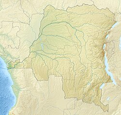
Relief location map of Democratic_Republic_of_the_Congo.
- Projection: Equirectangular projection, stretched by 100.0%.
- Geographic limits of the map:
- N: 6.0° N
- S: -14.0° N
- W: 11.0° E
- E: 32.0° E
- GMT projection: -JX19.473333333333333cd/18.546031746031744cd
- GMT region: -R11.0/-14.0/32.0/6.0r
- GMT region for grdcut: -R11.0/-14.0/32.0/6.0r
- Relief: SRTM30plus.
- Made with Natural Earth. Free vector and raster map data @ naturalearthdata.com.


