U.S. Highway 101
| Karte | ||||||||||||||||||||||||||||||||||||||||
|---|---|---|---|---|---|---|---|---|---|---|---|---|---|---|---|---|---|---|---|---|---|---|---|---|---|---|---|---|---|---|---|---|---|---|---|---|---|---|---|---|
 | ||||||||||||||||||||||||||||||||||||||||
| Basisdaten | ||||||||||||||||||||||||||||||||||||||||
| Gesamtlänge: | 1540mi /2478 km | |||||||||||||||||||||||||||||||||||||||
| Eröffnung: | 1936 | |||||||||||||||||||||||||||||||||||||||
| Bundesstaaten: | Kalifornien Oregon Washington | |||||||||||||||||||||||||||||||||||||||
| Anfangspunkt: | ||||||||||||||||||||||||||||||||||||||||
| Endpunkt: | ||||||||||||||||||||||||||||||||||||||||
Verlauf
| ||||||||||||||||||||||||||||||||||||||||
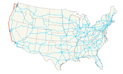
Der U.S. Highway 101 (oder U.S. Route 101) ist ein 2.471 Kilometer (1535 Meilen) langer und in Nord-Süd-Richtung verlaufender US-amerikanischer Highway in den US-Bundesstaaten Washington, Oregon und Kalifornien entlang der Pazifikküste der USA.
Allgemeines
Der Highway 101 trägt noch weitere inoffizielle Namen, etwa „Olympic Highway“ (im Staat Washington), „Pacific Coast Highway“ (Oregon), „Redwood Highway“ oder „El Camino Real“ (in Kalifornien).[1] Trotz seiner irreführenden dreistelligen Nummer, die normalerweise für Zubringerstraßen (englisch spur routes) verwendet wird, ist der U.S. Highway 101 eine Hauptstraße (englisch major route) im United States Numbered Highway System. Folgt man diesem System, wäre der US-101 der Zubringer für den – an der Ostküste der Vereinigten Staaten verlaufenden – U.S. Highway 1, was nicht zutrifft. Vielmehr gilt die „10“ hierbei als die erste Ziffer, da der nächst östliche (heutzutage nicht mehr existente) Nord-Süd-Highway der US 99 war. Große Streckenabschnitte der Fernstraße US-101 gelten als Panoramastraße.
Geschichte
Nachdem die American Association of State Highway and Transportation Officials die Straßenbauplanungen bis Dezember 1925 abgeschlossen hatte, begannen die drei beteiligten Bundesstaaten unabhängig voneinander mit dem Straßenbau. Im Januar 1928 wurde in Kalifornien der erste Streckenabschnitt zwischen San Diego und Los Angeles dem Verkehr übergeben. Die Fertigstellung in Washington erfolgte im Mai 1931[2], im Oktober 1936 folgte der Straßenabschnitt in Oregon.
Verlauf
Der Highway verläuft entweder direkt an der Pazifikküste (im nördlichen Abschnitt) oder weiter im Inland (im südlichen Teil).
| US-Bundesstaat | Streckenlänge in km | Streckenlänge in mi |
|---|---|---|
| 588 | 366 | |
| 585 | 363 | |
| 1298 | 806 | |
| gesamt | 2471 | 1535 |
Rund 54 % der Gesamtstrecke entfällt auf Kalifornien, die beiden anderen Bundesstaaten besitzen einen Anteil von jeweils 23 %. In beteiligten Bundesstaaten ist der US-101 der längste Highway.
Übersicht
| Ortschaft | Entfernung in km | Entfernung in mi |
|---|---|---|
| Tumwater, | 0 | 0 |
| Port Angeles | 190 | 119 |
| Forks | 90 | 56 |
| Aberdeen | 171 | 107 |
| Long Beach | 114 | 71 |
| Grenze zwischen | ||
| Astoria | 30 | 19 |
| Seaside | 27 | 17 |
| Bay City | 69 | 43 |
| Lincoln City | 78 | 49 |
| Newport | 40 | 25 |
| Florence | 78 | 49 |
| Port Orford | 156 | 99 |
| Gold Beach | 45 | 28 |
| Grenze zwischen | ||
| Smith River | 93 | 58 |
| Crescent City | 21 | 13 |
| McKinleyville | 114 | 71 |
| Eureka | 21 | 14 |
| Miranda | 93 | 58 |
| Leggett | 57 | 36 |
| Laytonville | 35 | 22 |
| Ukiah | 73 | 46 |
| Cloverdale | 46 | 29 |
| Santa Rosa | 51 | 32 |
| San Rafael | 59 | 37 |
| Golden Gate Bridge | 19 | 12 |
| San Francisco | 11 | 7 |
| San Bruno | 19 | 12 |
| Redwood City | 24 | 15 |
| Palo Alto | 13 | 8 |
| San José | 27 | 17 |
| Gilroy | 51 | 32 |
| Salinas | 45 | 28 |
| El Paso de Robles | 156 | 99 |
| San Luis Obispo | 48 | 30 |
| Santa Maria | 51 | 32 |
| Santa Barbara | 101 | 63 |
| Ventura | 45 | 28 |
| Los Angeles, | 98 | 61 |
| gesamt | 2467 | 1542 |
Der U.S. Highway 101 beginnt und endet am Interstate Highway 5.
Bildergalerie
Einzelheiten
Der U.S. Highway 101 beginnt als Abzweig vom Interstate 5 in Tumwater südlich der Hauptstadt des Bundesstaates Washington, Olympia. Von dort verläuft er zunächst in nordwestlicher und dann in nördlicher Richtung zur Olympic-Halbinsel und führt dort um den Olympic-Nationalpark herum.[3] Port Angeles ist der nördlichste Teil des Highways und liegt an der Juan-de-Fuca-Straße, an deren nördlicher Seite sich in etwa 21 km Entfernung die kanadische Vancouver Island befindet. Hinter Forks nimmt der US-101 schließlich seine generelle Südrichtung ein. Noch im Bundesstaat Washington folgen Aberdeen und Long Beach.[4]
Zum Ort Astoria führt die 6545 Meter lange Astoria Bridge über den Columbia River, der die Grenze zu Oregon bildet. Erst die Fertigstellung der Brücke im Juli 1966 ermöglichte die hindernisfreie komplette Fahrt auf dem US-101. An diesem liegt das nach dem deutschstämmigen Pelzhändler Johann Jakob Astor benannte Astoria, der im Ort 1811 das „Fort Astoria“ gründete. In der Nähe von Port Orford führt der US-101 über die 1931 errichtete und 578 Meter lange Rogue River Bridge.
In Kalifornien erschließt der US-101 zunächst den Redwood-Nationalpark mit den spektakulären Küstenmammutbäumen innerhalb eines gemäßigten Regenwalds. Das vom Park umschlossene und 1851 von Goldsuchern gegründete Crescent City lebt heute vom Parktourismus. Die zur Kleinstadt gehörige Bucht ist die anfälligste für Flutwellen in den gesamten USA.[5] Der US-101 führt östlich an Leggett vorbei, wo die nach Süden verlaufende California State Route 1 beginnt. Santa Rosa befindet sich im Zentrum des nordkalifornischen Wine Country, wo sie als County Seat des Sonoma County fungiert.[6] Einen der touristischen Höhepunkte bildet die 2737 Meter lange Golden Gate Bridge, über die der US-101 nach San Francisco führt. In der Stadt hat er den Straßennamen „Van Ness Avenue“[7], die südlich aus der Stadt hinausführt. In San Bruno beginnt das um den US-101 gelegene Silicon Valley mit weltmarktführenden Unternehmen der Informationstechnologie, das in Stanford mit der Stanford University auch eine wissenschaftliche Fundierung besitzt und sich etwa bis San José ausdehnt. In dem 1772 gegründeten San Luis Obispo befindet sich die Mission San Luis Obispo de Tolosa. Über Ventura wird schließlich Los Angeles erreicht, wo der US-101 als „Santa Ana Freeway“ im Interstate Highway 5 aufgeht.
Trivia
In der Cartoon-Serie Die Simpsons wird in Staffel 18/Episode 7 (2024) eine Straßenkreuzung zwischen dem Interstate Highway 405 und dem US-101 erwähnt, an welcher der Simpsons-Wohnort Springfield liegen soll. Diese Kreuzung existiert tatsächlich in Sherman Oaks, einem Stadtteil von Los Angeles.
Siehe auch
Weblinks
- End of US Highways (englisch)
Einzelnachweise
- ↑ Ralph E. Nelson, Soil Survey, San Mateo Area, California, 1961, S. 83
- ↑ United States/Federal Highway Administration (Hrsg.), US-101, Palix River Bridge Replacement, Pacific County, 1986, S. 3
- ↑ Don Young/Marjorie Young, Adventure Guide to the Pacific Northwest, 1965, S. 208
- ↑ Don Young, Pacific Northwest Adventure Guide, 2009, S. 208
- ↑ The New York Times vom 16. März 2011, Sleepy California Town, and a Tsunami Magnet
- ↑ Simone Wilson, Santa Rosa, 2004, S. 16
- ↑ benannt nach James Van Ness, dem Bürgermeister von San Francisco 1855/1856
Auf dieser Seite verwendete Medien
Flag of California. This version is designed to accurately depict the standard print of the bear as well as adhere to the official flag code regarding the size, position and proportion of the bear, the colors of the flag, and the position and size of the star.
750 mm × 600 mm (30 in × 24 in) U.S. Highway shield, made to the specifications of the 2004 edition of Standard Highway Signs. (Note that there is a missing "J" label on the left side of the diagram.) Uses the Roadgeek 2005 fonts. (United States law does not permit the copyrighting of typeface designs, and the fonts are meant to be copies of a U.S. Government-produced work anyway.)
Autor/Urheber: Adbar, Lizenz: CC BY-SA 3.0
US 101 in the Mendocino County (Mile 102).
600 mm × 600 mm (24 in × 24 in) U.S. Highway shield, made to the specifications of the 2004 edition of Standard Highway Signs. (Note that there is a missing "J" label on the left side of the diagram.) Uses the Roadgeek 2005 fonts. (United States law does not permit the copyrighting of typeface designs, and the fonts are meant to be copies of a U.S. Government-produced work anyway.)
600 mm × 600 mm (24 in × 24 in) U.S. Highway shield, made to the specifications of the 2004 edition of Standard Highway Signs. (Note that there is a missing "J" label on the left side of the diagram.) Uses the Roadgeek 2005 fonts. (United States law does not permit the copyrighting of typeface designs, and the fonts are meant to be copies of a U.S. Government-produced work anyway.)
Flag of Oregon (obverse): The flag was adopted by the state on February 26, 1925.[1] The state seal was decided in 1903.[2][3]
Autor/Urheber: Alfa117, Lizenz: CC BY-SA 3.0
Santa Ana Freeway (US 101) kurz vor der Four Level Interchange mit der "110" in LA Civic Center. Linkerhand ist die Cathedral of our Lady of the Angels zu sehen.
Autor/Urheber: Cacophony, Lizenz: CC BY-SA 3.0
The Isaac Lee Patterson Bridge viewed from the southeast.
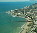
An aerial view of Ventura, California.
Autor/Urheber: Aslak Raanes aus Trondheim, Norway, Lizenz: CC BY 2.0
like many other pictures of the golden gate
golden gate
Blick auf den US Highway 101, im Hintergrund die Cathedral of our Lady of the Angels
Autor/Urheber: Daniel Hershman from Federal Way, US, Lizenz: CC BY 2.0
Oregon coast, Hunter's Cove, north of Cape Sebastian, Highway 101
Autor/Urheber: SounderBruce, Lizenz: CC BY-SA 4.0
A reassurance shield at the northern terminus of U.S. Route 101 at an interchange with Interstate 5 in Tumwater, Washington (near Olympia).
600 mm × 600 mm (24 in × 24 in) U.S. Highway shield, made to the specifications of the 2004 edition of Standard Highway Signs. (Note that there is a missing "J" label on the left side of the diagram.) Uses the Roadgeek 2005 fonts. (United States law does not permit the copyrighting of typeface designs, and the fonts are meant to be copies of a U.S. Government-produced work anyway.)
600 mm × 600 mm (24 in × 24 in) U.S. Highway shield, made to the specifications of the 2004 edition of Standard Highway Signs. (Note that there is a missing "J" label on the left side of the diagram.) Uses the Roadgeek 2005 fonts. (United States law does not permit the copyrighting of typeface designs, and the fonts are meant to be copies of a U.S. Government-produced work anyway.)
Autor/Urheber: Visitor7, Lizenz: CC BY-SA 3.0
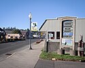
The Taft neighborhood in Lincoln City on U.S. Route 101 in Oregon
Autor/Urheber: Klaus with K, Lizenz: CC BY-SA 4.0
Die Astoria-Megler-Brücke fotografiert von der Südrampe. Entzerrt mittels hugin.
(c) Coolcaesar aus der englischsprachigen Wikipedia, CC BY-SA 3.0
The view seen by vehicles descending the Cuesta Grade segment of U.S. Route 101 between San Luis Obispo and Atascadero. This photograph is deceiving; the road is much steeper than it appears in this image.
750 mm × 600 mm (30 in × 24 in) U.S. Highway shield, made to the specifications of the 2004 edition of Standard Highway Signs. (Note that there is a missing "J" label on the left side of the diagram.) Uses the Roadgeek 2005 fonts. (United States law does not permit the copyrighting of typeface designs, and the fonts are meant to be copies of a U.S. Government-produced work anyway.)
We just can't get enough of these #FallColors along Highway 101. Brilliant!
Autor/Urheber: Famartin, Lizenz: CC BY-SA 4.0
View north along U.S. Route 101 (Bayshore Freeway) at Exit 433B (Interstate 80/Bay Bridge) in San Francisco, California
Autor/Urheber: Kéiryn, Lizenz: CC BY 3.0
U.S. Route 101 approaching downtown Aberdeen
600 mm × 600 mm (24 in × 24 in) U.S. Highway shield, made to the specifications of the 2004 edition of Standard Highway Signs. (Note that there is a missing "J" label on the left side of the diagram.) Uses the Roadgeek 2005 fonts. (United States law does not permit the copyrighting of typeface designs, and the fonts are meant to be copies of a U.S. Government-produced work anyway.)
600 mm by 600 mm (24 in by 24 in) Interstate shield, made to the specifications of the 2004 edition of Standard Highway Signs (sign M1-1). Uses the Roadgeek 2005 fonts. (United States law does not permit the copyrighting of typeface designs, and the fonts are meant to be copies of a U.S. Government-produced work anyway.) Colors are from [1] (Pantone Red 187 and Blue 294), converted to RGB by [2]. The outside border has a width of 1 (1 mm) and a color of black so it shows up; in reality, signs have no outside border.
