Teall-Nunatak
| Teall-Nunatak | ||
|---|---|---|
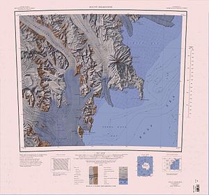
 Topografische Karte mit dem Teall-Nunatak (links unten) | ||
| Höhe | 1190 m | |
| Lage | Viktorialand, Ostantarktika | |
| Gebirge | Transantarktisches Gebirge | |
| Koordinaten | 74° 50′ 0″ S, 162° 33′ 0″ O | |
Der Teall-Nunatak ist ein 1190 m hoher Nunatak im ostantarktischen Viktorialand. Er ragt rund 5 km südöstlich des Hansen-Nunatak in der Entstehungszone des Reeves-Gletschers auf.
Teilnehmer der Nimrod-Expedition (1907–1909) unter der Leitung des britischen Polarforschers Ernest Shackleton entdeckten ihn. Benannt ist er nach Jethro Teall (1849–1924), einem britischen Geologen und Petrologen.
Siehe auch
Weblinks
- Teall Nunatak. In: Geographic Names Information System. United States Geological Survey, United States Department of the Interior, archiviert vom (englisch).
- Teall Nunatak auf geographic.org (englisch)
- Teall Nunatak. In: Kenneth J. Bertrand und Fred G. Alberts, Geographic names of Antarctica, U.S. Govt. Print. Off., Washington 1956, S. 298 (englisch)
Auf dieser Seite verwendete Medien
Autor/Urheber: Alexrk2, Lizenz: CC BY-SA 3.0
Physische Positionskarte Antarktis, Mittabstandstreue Azimutalprojektion
1:250,000-scale topographic reconnaissance map of the Mount Melbourne area from 162°-166°30'E to 74°-75°S in Antarctica. Mapped, edited and published by the U.S. Geological Survey in cooperation with the National Science Foundation.


