Strandavatnet
| Strandavatnet | |||
|---|---|---|---|
 | |||
| Lage | Provinz Buskerud, Norwegen | ||
| Zuflüsse | Urevassfjorden, Byrkjedøla, Raggsteindøla | ||
| Abfluss | Storåne → Holselva → Hallingdalselva | ||
| Größere Orte in der Nähe | Myrland (Hol) | ||
| |||
| Koordinaten | 60° 41′ 41″ N, 7° 51′ 29″ O | ||
| Daten zum Bauwerk | |||
| Bauzeit | 1952/1953 | ||
| Daten zum Stausee | |||
| Höhenlage (bei Stauziel) | 978 moh. | ||
| Wasseroberfläche | 24,07 km² | ||
| Stauseelänge | 12,2 km | ||
| Stauseebreite | 4,5 km | ||
| Gesamtstauraum | 554 Mm³ | ||
| Einzugsgebiet | 268,72 km² | ||
Der Strandavatnet ist ein norwegischer Stausee in der Gemeinde Hol, in der Provinz Buskerud. Die Wasseroberfläche beträgt rund 23,75 km². Die Höhe der Wasseroberfläche bei Vollstau liegt bei rund 978 moh. Bedingt durch die 1952/1953 errichtete, 28 m hohe Staumauer schwankt der Wasserstand und kann bis auf ca. 950 moh. absinken. Im Südosten teilt sich der See in die zwei Arme Faugelifjorden und Stryknasfjorden auf.[1] Zudem ragt dort die Oddelii-Halbinsel in den See, deren höchste Erhebung der Oddefjellet mit 1115 moh. darstellt.[1]
Bilder
 Der zugefrorene Strandavatnet im Mai 2013, Blick vom nördlichen Seeufer auf die Berge Storeskuta und Folarskardnuten
 Blick vom nördlichen Seeufer auf den Storeskuta und die Hallingskarvet-Berge
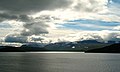 Blick über den Strandavatnet (September 2012)
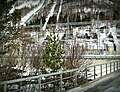 Wasserkraftwerk Hovet
 Green energy to Oslo

Siehe auch
Einzelnachweise
- ↑ a b Karte des Strandavatnet (Seite nicht mehr abrufbar, festgestellt im Mai 2019. Suche in Webarchiven) Info: Der Link wurde automatisch als defekt markiert. Bitte prüfe den Link gemäß Anleitung und entferne dann diesen Hinweis., ut.no, abgerufen am 29. Dezember 2011 (norwegisch)
Auf dieser Seite verwendete Medien
Strandavatnet, Hovet.jpg
Autor/Urheber: E-CO, Lizenz: CC BY-SA 3.0
Strandavatnet is a lake in Hovet, Hol Kommune.
Autor/Urheber: E-CO, Lizenz: CC BY-SA 3.0
Strandavatnet is a lake in Hovet, Hol Kommune.
The lake is a reservoir for the Rud hydroelectric powerstation in Hovet. In 1952/1953 a dam was constructed which lifted the lake level 28 meters, thus the lake varies between 950 and 978 m above sea level.
There is a dam at Strandavatnet. In fact it was the first rock filling (embankment) dam in Norway. You can see it on your left hand side from Riksvei 50 at Myrland (the road to Raggsteindalen goes over the dam).
Norway Buskerud rel location map.svg
(c) Karte: NordNordWest, Lizenz: Creative Commons by-sa-3.0 de
Positionskarte von Buskerud, Norwegen
(c) Karte: NordNordWest, Lizenz: Creative Commons by-sa-3.0 de
Positionskarte von Buskerud, Norwegen
Electricity transport, from Hovet to Oslo.jpg
Autor/Urheber: DutchColours, Lizenz: CC BY-SA 3.0
The full 100 percent of the created electricity in the Hol I power station of Hovet goes to Oslo, where it is used in 17.500 houses. The power station is owned by E-Co Energi, the customers are served by Hafslund ASA.
Autor/Urheber: DutchColours, Lizenz: CC BY-SA 3.0
The full 100 percent of the created electricity in the Hol I power station of Hovet goes to Oslo, where it is used in 17.500 houses. The power station is owned by E-Co Energi, the customers are served by Hafslund ASA.

Strandavatnet, and the Hallingskarvet mountain area..jpg
Autor/Urheber: DutchColours, Lizenz: CC BY-SA 3.0
Strandavatnet was frozen even end of May. The view however is as always extraordinary, fascinating, because of the mountains on the background. They belong to National Park Hallingskarvet.
Autor/Urheber: DutchColours, Lizenz: CC BY-SA 3.0
Strandavatnet was frozen even end of May. The view however is as always extraordinary, fascinating, because of the mountains on the background. They belong to National Park Hallingskarvet.

A frozen Strandavatnet.jpg
Autor/Urheber: DutchColours, Lizenz: CC BY-SA 3.0
Strandavatnet was frozen even end of May (2013). The view however is as always extraordinary, fascinating, because of the mountains on the background. They belong to National Park Hallingskarvet.
Autor/Urheber: DutchColours, Lizenz: CC BY-SA 3.0
Strandavatnet was frozen even end of May (2013). The view however is as always extraordinary, fascinating, because of the mountains on the background. They belong to National Park Hallingskarvet.

Powerstation, Hovet.jpg
Autor/Urheber: DutchColours, Lizenz: CC BY-SA 3.0
When you enlarge the photo you can see the two pipes from the top of the mountain, downward, to the powerstation. The left one contains water from the Strandavatnet, and belongs to the Urunda watercourse; the right one belongs to the Votna watercourse.

Strandavatnet.jpg
Autor/Urheber: DutchColours, Lizenz: CC BY-SA 3.0
Strandavatnet is a lake in Hol municipality, Buskerud county, Norway. The lake covers an area of 23.75 square kilometres (9.17 sq mi), and lies 975 metres (3,199 ft) above sea level.' The lake is a reservoir for the Rud hydroelectric powerstation in Hovet. In 1952/1953 a dam was constructed which lifted the lake level 28 meters, thus the lake varies between 950 and 978 m above sea level. (Infoː wiki)