Shorty (Mondkrater)
| Shorty | ||
|---|---|---|
 | ||
| ||
| Position | 20,22° N, 30,63° O | |
| Durchmesser | 110 m | |
| Tiefe | 14 m | |
| Benannt nach | Der Krater wurde von den Astronauten benannt, um das Genre der Kurzgeschichte zu ehren, besonders die von Richard Brautigan und J. D. Salinger[1] | |
| Benannt seit | 1973 | |
| Sofern nicht anders angegeben, stammen die Angaben aus dem Eintrag in der IAU/USGS-Datenbank | ||
Shorty ist ein Krater auf dem Mond der Erde, er ist ein wahrscheinlich vulkanischer Krater im Taurus-Littrow-Tal. Die beiden Astronauten Eugene Cernan und Harrison Schmitt besuchten ihn 1972 im Zuge der Apollo-17-Mission. Es ist die Lage des berühmten orangen Bodens.

Panorama-Kamera-Bild der Apollo 17
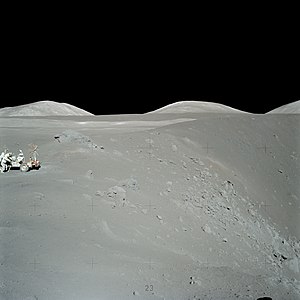
Erkundung des Shorty-Kraters während der Apollo-17-Mission auf den Mond. Der orange Boden fand sich rechts vom Rover, am Fuße des kleinen Hügels am Kraterrand.

Ansicht auf den Shorty-Krater.
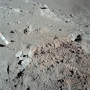
Oranger Boden direkt neben Shorty, der aus titanreichem pyroklastischem Glas besteht[2]
Siehe auch
- Liste der Mondkrater
Literatur
- Elijah E. Cocks, Josiah C. Cocks: Who’s who on the moon. A biographical dictionary of lunar nomenclature. Updated and revised edition, 2nd edition. Tudor Publishers, Greensboro NC 2009, ISBN 978-0-9778026-1-6.
- Antonín Rükl: Mondatlas. Werner Dausien, Hanau 1990, ISBN 3-7684-2047-7.
Weblinks
Commons: Shorty Krater – Sammlung von Bildern, Videos und Audiodateien
- Apollo Image Gallery
- Tsiolkovskiy im Gazetteer of Planetary Nomenclature der IAU (WGPSN) / USGS
Einzelnachweise
- ↑ Shorty, International Astronomical Union (IAU) Working Group for Planetary System Nomenclature (WGPSN) (englisch)
- ↑ LROC - Just Another Crater? (englisch)
Auf dieser Seite verwendete Medien

Apollo 17 orange soil.jpg
Close-up of the orange soil discovered on the Apollo 17 mission in 1972. The color is caused by microscopic glass beads created by volcanic processes earlier in the Moon's history. This is NASA photo AS17-137-20986, File:Orange Soil Discovery - GPN-2000-001152.jpg.
Close-up of the orange soil discovered on the Apollo 17 mission in 1972. The color is caused by microscopic glass beads created by volcanic processes earlier in the Moon's history. This is NASA photo AS17-137-20986, File:Orange Soil Discovery - GPN-2000-001152.jpg.

Shorty crater AS17-P-2750 ASU.jpg
Autor/Urheber: James Stuby based on NASA image
, Lizenz: CC0
Shorty crater, Taurus–Littrow valley, on the moon. Sun elevation 46 deg., spacecraft altitude 112 km. Scaled image 200% due to small size of original.
Autor/Urheber: James Stuby based on NASA image
, Lizenz: CC0
Shorty crater, Taurus–Littrow valley, on the moon. Sun elevation 46 deg., spacecraft altitude 112 km. Scaled image 200% due to small size of original.

As17-137-21009.jpg
Image taken during the Apollo 17 mission to the Moon, in the Taurus-Littrow region. The NASA description reads:
This photo was used in Figure 5-28 of the Apollo 17 Preliminary Science Report (SP-330, 1973), which has the following caption:
The southern rim of Shorty Crater looking west. The sampled orange soil deposit is at the left center of the photograph near the large boulder. Note the heterogeneity of boulder and albedo distribution patterns. The crater is approximately 110 m in diameter.

Moon Map - Equatorial region 45S to 45N - LPC1 - NASA.jpg
NASA lunar chart of equatorial region (latitudes 45S to 45N) 1 : 10.000.000 (LPC-1).
NASA lunar chart of equatorial region (latitudes 45S to 45N) 1 : 10.000.000 (LPC-1).

As17-137-20992.jpg
AS17-137-20992 (12 Dec. 1972) --- A view looking into Shorty Crater, taken at Station 4, showing the orange soil. Astronaut Harrison H. Schmitt found the orange soil on the moon during the second Apollo 17 extravehicular activity (EVA) at the Taurus-Littrow landing site. While astronauts Eugene A. Cernan, commander, and Schmitt, lunar module pilot, descended in the Lunar Module (LM) "Challenger" to explore the Taurus-Littrow region of the moon, astronaut Ronald E. Evans, command module pilot, remained with the Command and Service Modules (CSM) "America" in lunar orbit.
AS17-137-20992 (12 Dec. 1972) --- A view looking into Shorty Crater, taken at Station 4, showing the orange soil. Astronaut Harrison H. Schmitt found the orange soil on the moon during the second Apollo 17 extravehicular activity (EVA) at the Taurus-Littrow landing site. While astronauts Eugene A. Cernan, commander, and Schmitt, lunar module pilot, descended in the Lunar Module (LM) "Challenger" to explore the Taurus-Littrow region of the moon, astronaut Ronald E. Evans, command module pilot, remained with the Command and Service Modules (CSM) "America" in lunar orbit.
Shorty crater location AS17-151-23251.jpg
Autor/Urheber: James Stuby based on NASA image
, Lizenz: CC0
Green dot shows location of Shorty, Taurus-Littrow Valley, on the moon. Scale bar at lower right is 5 km.
Autor/Urheber: James Stuby based on NASA image
, Lizenz: CC0
Green dot shows location of Shorty, Taurus-Littrow Valley, on the moon. Scale bar at lower right is 5 km.