Shimokita-Halbinsel
| Shimokita-Halbinsel | ||
 Landsat-Aufnahme der Shimokita-Halbinsel | ||
| Geographische Lage | ||
| Koordinaten | 41° 12′ 0″ N, 141° 6′ 0″ O | |
| Gewässer 1 | Pazifischer Ozean, Tsugaru-Straße | |
| Gewässer 2 | Aomori-Bucht, Mutsu-Bucht | |
Die Shimokita-Halbinsel (jap. 下北半島, Shimokita-hantō) ist eine Halbinsel in der Präfektur Aomori am Nordende der Insel Honshū in Japan.
Die Halbinsel ragt nordwärts in die Tsugaru-Straße, die Honshū von Hokkaidō trennt. Gegenüber liegt die Kameda-Halbinsel der Oshima-Halbinsel. Die Ostküste liegt am Pazifischen Ozean, an der Westküste befinden sich die Aomori-Bucht und die Mutsu-Bucht.
Auf dieser Seite verwendete Medien
Opaque red circle
Autor/Urheber: Alexrk2, Lizenz: CC BY-SA 3.0
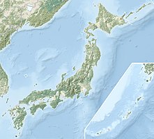
Natural Location map of Japan
Equirectangular projection.
Geographic limits to locate objects in the main map with the main islands:
- N: 45°51'37" N (45.86°N)
- S: 30°01'13" N (30.02°N)
- W: 128°14'24" E (128.24°E)
- E: 149°16'13" E (149.27°E)
Geographic limits to locate objects in the side map with the Ryukyu Islands:
- N: 39°32'25" N (39.54°N)
- S: 23°42'36" N (23.71°N)
- W: 110°25'49" E (110.43°E)
- E: 131°26'25" E (131.44°E)
Shimokita Peninsula, Aomori, Japan.


