Scallop Hill
| Scallop Hill | ||
|---|---|---|
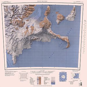
 Karte von Black Island (oben, rechte Bildhälfte) mit dem Scallop Hill | ||
| Höhe | 225 m | |
| Lage | Black Island, Ross-Archipel | |
| Koordinaten | 78° 12′ 0″ S, 166° 44′ 0″ O | |
Der Scallop Hill ist ein 225 m hoher Hügel vulkanischen Ursprungs in Form einer Kuppel. Er ragt unmittelbar hinter Cape Spirit auf der Ostseite von Black Island im antarktischen Ross-Archipel vor der Scott-Küste des Viktorialands auf.
Wissenschaftler einer von 1958 bis 1959 durchgeführten Kampagne im Rahmen der New Zealand Geological Survey Antarctic Expedition nahmen die Benennung vor. Namensgebend sind fossilierte Konglomerate von Kammmuscheln (englisch scallop) der Gattung Chlamys am Gipfel des Hügels.
Weblinks
- Scallop Hill im Geographic Names Information System des United States Geological Survey (englisch)
- Scallop Hill auf geographic.org (englisch)
Auf dieser Seite verwendete Medien
Autor/Urheber: Alexrk2, Lizenz: CC BY-SA 3.0
Physische Positionskarte Antarktis, Mittabstandstreue Azimutalprojektion
Map of Antarctica by the United States Antarctic Resource Center of the US Geological Society.


