Santa Isabel (Insel)
| Santa Isabel | |
|---|---|
 | |
| Gewässer | Pazifischer Ozean |
| Inselgruppe | Salomon-Inseln |
| Geographische Lage | 8° 0′ S, 159° 2′ O |
 | |
| Länge | 200 km |
| Breite | 22 km |
| Fläche | 2 999 km² |
| Höchste Erhebung | Sasari 1220 m |
| Einwohner | 26.158 (2009) 8,7 Einw./km² |
| Hauptort | Buala |
 | |

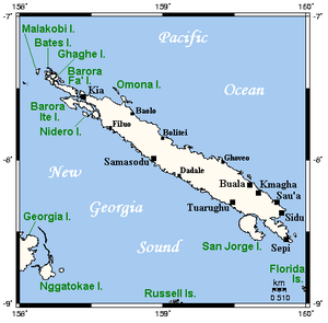
Santa Isabel (ehemals auch Ysabel) ist eine Insel der Provinz Isabel des pazifischen Inselstaats der Salomonen. Sie liegt zwischen den Inseln Choiseul und Malaita und grenzt südwestlich an den New-Georgia-Archipel.
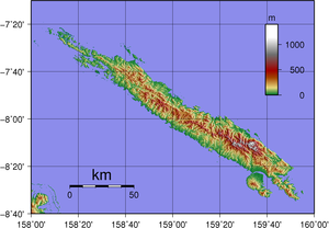
Die dicht bewaldete Insel ist vulkanischen Ursprungs und gehört zur Inselkette der südlichen Salomon-Inseln. Die längliche, knapp 3000 km² große Insel erstreckt sich von Norden nach Südosten über eine Länge von 200 Kilometern, ist aber im Schnitt nur 22 Kilometer breit.
Hauptort ist Buala, gelegen an der Küste im Südosten der Insel.
Santa Isabel gehörte, wie die Nachbarinseln der Provinz und Choiseul, von 1886 bis zum Samoa-Vertrag zum deutschen Kolonialreich im Pazifik.[1] 1899 ging sie an Großbritannien.
Weblinks
Einzelnachweise
- ↑ O. N.: Ysabel ( des vom 30. Oktober 2013 im Internet Archive) Info: Der Archivlink wurde automatisch eingesetzt und noch nicht geprüft. Bitte prüfe Original- und Archivlink gemäß Anleitung und entferne dann diesen Hinweis., in: Heinrich Schnee (Hrsg.): Deutsches Kolonial-Lexikon. Band III, Quelle & Meyer, Leipzig 1920, S. 735.
Auf dieser Seite verwendete Medien
Topographical map of Santa Isabel in Solomon Islands.
Kaiser-Wilhelms-Land, Marshall-Inseln, Salomonen (heute Papua-Neuguinea, Marshall-Inseln, Salomonen)
Autor/Urheber: This map's source is here, with the uploader's modifications, and the GMT homepage says that the tools are released under the GNU General Public License., Lizenz: CC BY-SA 3.0
Map of Santa Isabel and neighbouring islands in the Solomon Islands.
Island of Solomon Islands - Santa Isabel.PNG


