Rennick-Gletscher
| Rennick-Gletscher | ||
|---|---|---|
| Lage | Viktorialand, Ostantarktika | |
| Gebirge | Transantarktisches Gebirge | |
| Länge | 320 km | |
| Breite | max. 48 km | |
| Koordinaten | 70° 30′ S, 160° 45′ O | |
| ||
| Entwässerung | Rennick Bay | |
Der Rennick-Gletscher ist ein fast 320 km langer und bis zu 48 km breiter Gletscher im ostantarktischen Viktorialand, der zu den größten Gletschern Antarktikas zählt. Er fließt vom Polarplateau, wo er seine größte Breite erreicht, bis zur Rennick Bay an der Oates-Küste, wo er sich auf ungefähr 15 km verschmälert und in die Somow-See entwässert.
Der untere Gletscherabschnitt wurde während der Operation Highjump (1946–1947) fotografiert. In den frühen 1960er Jahren evakuierte Lieutenant Commander Robert L. Dale, ein Pilot der Flugerstaffel VX-6 der United States Navy, eine Untersuchungsmannschaft des United States Antarctic Program von der Gletscheroberfläche bei 72° 38′ S, 161° 32′ O. Benannt ist er in Verbindung mit der gleichnamigen Bucht nach Henry Edward de Parny Rennick (1881–1914), einem Schiffsoffizier auf der Terra Nova bei der nach dieser benannten Expedition (1910–1913) unter der Leitung des britischen Polarforschers Robert Falcon Scott.
Weblinks
- Rennick Glacier auf geographic.org (englisch)
- Rennick Glacier. In: Geographic Names Information System. United States Geological Survey, United States Department of the Interior, archiviert vom (englisch). (englisch)

Kartenblatt Ob’ Bay von 1967, Nordostteil des Rennick-Gletschers am westlichen Kartenrand

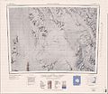
Kartenblatt Pomerantz Tableland mit dem Nordwestteil des Rennick-Gletschers

Kartenblatt Mount Soza von 1967, Mittelteil des Rennick-Gletschers im Westen der Karte
Kartenblatt Freyberg Mountains von 1967, Südteil des Rennick-Gletschers im Westen der Karte
Auf dieser Seite verwendete Medien

Autor/Urheber: Alexrk2, Lizenz: CC BY-SA 3.0
Physische Positionskarte Antarktis, Mittabstandstreue Azimutalprojektion

1:250,000-scale topographic reconnaissance map of the Ob' Bay area from 162°-165°E to 70°-71°S in Antarctica, including Lillie Glacier. Mapped, edited and published by the U.S. Geological Survey in cooperation with the National Science Foundation.

1:250,000-scale topographic reconnaissance map of the Freyberg Mountains area from 162°-163°30'E to 72°-73°S in Antarctica, including the Evans Névé. Mapped, edited and published by the U.S. Geological Survey in cooperation with the National Science Foundation.

1:250,000-scale topographic reconnaissance map of the Pomerantz Tableland area from 159°-162°E to 70°-71°S in Antarctica, including parts of the Usarp Mountains and the Rennick Glacier. Mapped, edited and published by the U.S. Geological Survey in cooperation with the National Science Foundation.

1:250,000-scale topographic reconnaissance map of the Bowers Mountains area from 162°-165°E to 71°-72°S in Antarctica, including Mount Soza and Rennick and Lillie Glaciers. Mapped, edited and published by the U.S. Geological Survey in cooperation with the National Science Foundation.