Rancho Murieta
| Rancho Murieta | ||
|---|---|---|
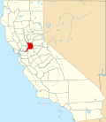
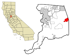
Lage in Kalifornien | ||
| Basisdaten | ||
| Staat: | Vereinigte Staaten | |
| Bundesstaat: | Kalifornien | |
| County: | Sacramento County | |
| Koordinaten: | 38° 30′ N, 121° 5′ W | |
| Zeitzone: | Pacific (UTC−8/−7) | |
| Einwohner: | 5.903 (Stand: 2020) | |
| Haushalte: | 2.333 (Stand: 2020) | |
| Fläche: | 31,3 km2 (ca. 12 mi²) davon 30,8 km2 (ca. 12 mi²) Land | |
| Bevölkerungsdichte: | 192 Einwohner je km2 | |
| Höhe: | 51 m | |
| Postleitzahl: | 95683 | |
| Vorwahl: | +1 916 | |
| FIPS: | 06-59506 | |
| GNIS-ID: | 1820537 | |
 | ||
Rancho Murieta ist ein census-designated place (CDP) im Sacramento County im US-Bundesstaat Kalifornien mit 5903 Einwohnern (Stand: 2020).[1]
Das Gebiet, das einen gleichnamigen Flughafen (IATA: RIU) beherbergt, bildet etwa 30 km östlich von Sacramento den Kern der Weinbauregion Sloughhouse AVA.
Einzelnachweise
- ↑ U.S. Census Bureau QuickFacts: Rancho Murieta CDP, California. In: census.gov. 1. Juli 2023, abgerufen am 2. Juni 2024.
Auf dieser Seite verwendete Medien
Autor/Urheber: NordNordWest, Lizenz: CC BY 3.0
Positionskarte von Kalifornien, USA
Autor/Urheber: Arkyan, Lizenz: CC BY-SA 3.0
This map shows the incorporated and unincorporated areas in Sacramento County, California, highlighting Rancho Murieta in red. It was created with a custom script with US Census Bureau data and modified with Inkscape.


