Peach Springs
| Peach Springs | |
|---|---|
 | |
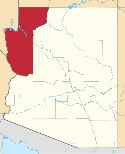
| Lage im Mohave County und in Arizona | |
| Basisdaten | |
| Staat: | Vereinigte Staaten |
| Bundesstaat: | Arizona |
| County: | Mohave County |
| Koordinaten: | 35° 32′ N, 113° 25′ W |
| Zeitzone: | Mountain Standard Time (UTC−7) |
| Einwohner: | 1.098 (Stand: 2020) |
| Haushalte: | 420 (Stand: 2020) |
| Fläche: | 17,9 km² (ca. 7 mi²) davon 17,8 km² (ca. 7 mi²) Land |
| Bevölkerungsdichte: | 62 Einwohner je km² |
| Höhe: | 1457 m |
| Postleitzahl: | 86434 |
| Vorwahl: | +1 928 |
| FIPS: | 04-53770 |
| GNIS-ID: | 0009278 |
Peach Springs ist ein Census-designated place im Mohave County im US-Bundesstaat Arizona. Das U.S. Census Bureau hat bei der Volkszählung 2020 eine Einwohnerzahl von 1.098[1] ermittelt.
Das Dorf liegt in der Nähe vom Coconino County und Yavapai County. Peach Springs wird von der Arizona State Route 66 tangiert. Peach Springs hat eine Fläche von 17,9 km². Die Bevölkerungsdichte liegt bei 62 Einwohnern pro km².
Die Stadt ist die einzige Siedlung im Hualapai-Indianerreservat und der Hauptort des Volkes.
Trivia
Die Stadt Peach Springs war die Inspiration für die fiktive Stadt Radiator Springs im Film Cars.
Weblinks
Einzelnachweise
- ↑ Explore Census Data Peach Springs CDP, Arizona. Abgerufen am 22. Oktober 2022.
Auf dieser Seite verwendete Medien
Autor/Urheber: Arkyan, Lizenz: CC BY-SA 3.0
This map shows the incorporated and unincorporated areas and Indian reservations in Mohave County, Arizona, highlighting Peach Springs in red. I created it in Inkscape using data from the US Census Bureau and the Mohave County website.
Autor/Urheber: Alex Alishevskikh, Lizenz: CC BY-SA 2.0
Peach Springs, Arizona.


