Newtowncunningham
| Newtowncunningham An Baile Nua Newtown Cunningham Newtowncunningham | |||
|---|---|---|---|
| |||
| Koordinaten | 54° 59′ 53″ N, 7° 30′ 50″ W | ||
| Basisdaten | |||
| Staat | Irland | ||
| Provinz | Ulster | ||
| Grafschaft | Donegal | ||
| ISO 3166-2 | IE-DL | ||
| Höhe | 10 m | ||
| Fläche | 0,7 km² | ||
| Einwohner | 1192 (2022[1]) | ||
| Dichte | 1.603,4 Ew./km² | ||
| Telefonvorwahl | +353 (0)71 | ||
Newtowncunningham (auch: Newton oder Newtown Cunningham, irisch An Baile Nua, deutsch neue Stadt) ist eine Küstenstadt im County Donegal im Nordwesten der Republik Irland mit 1192 Einwohnern.[1] Die Bevölkerung hat sich seit 1991 nahezu verdoppelt.
Geografie und Daten
Newtowncunningham liegt etwa neun Kilometer ostnordöstlich von Letterkenny und etwa neun Kilometer westlich von Derry. Durch die Ortschaft führt die N13, von der östlich die R237 abgeht. Nördlich von Newtowncunningham liegt Lough Swilly.
Geschichte
Der Name der Gegend war ursprünglich Culmacatrain. Der heutige Name ist John Cunningham, einem schottischen Siedler entlehnt.
Sehenswürdigkeiten
- katholische Allerheiligen-Kirche
- anglikanische Allerheiligen-Kirche
- presbyterianische Kirche
- Burt Castle im Nordosten Newtowncunninghams
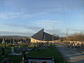 Katholische Kirche
 (c) Kenneth Allen, CC BY-SA 2.0Anglikanische Kirche
 (c) Kenneth Allen, CC BY-SA 2.0Presbyterianische Kirche
Persönlichkeiten
- George Ferguson Bowen (1821–1899), irischer Politiker und Gouverneur von Queensland, Neuseeland, Mauritius und Hongkong
Weblinks
Einzelnachweise
- ↑ a b Newtowncunningham auf citypopulation.de, abgerufen am 13. Dezember 2024
| Towns | Ballybofey | Ballyshannon | Buncrana | Bundoran | Carndonagh | Castlefin | Donegal | Dungloe | Falcarragh | Glenties | Killybegs | Letterkenny | Lifford | Ramelton | Stranorlar | |
| Dörfer | Annagry | Ardara | Ballindrait | Ballintra | Ballyliffin | Bridgend | Bruckless | Burnfoot | Burtonport | Carrick | Carrigans | Carrigart | Churchill | Cloghan | Clonmany | Convoy | Cranford | Creeslough | Crolly | Culdaff | Doochary | Downings | Drumkeen | Dunfanaghy | Dunkineely | Dunlewey | Fahan | Fintown | Frosses | Glen | Glencolmcille | Greencastle | Inver | Kerrykeel | Kilcar | Killea | Killygordon | Kilmacrennan | Laghy | Leabgarrow | Lettermacaward | Loughanure | Malin | Malin Beg | Manorcunningham | Meenlaragh | Milford | Mountcharles | Moville | Muff | Narin | Newtowncunningham | Pettigo | Porthall | Portnablagh | Quigley’s Point | Raphoe | Rathmullan | Redcastle | Rossnowlagh | Shrove | St. Johnston | Teelin | Termon |
Auf dieser Seite verwendete Medien

Autor/Urheber: MaxPride, Lizenz: CC BY-SA 3.0
Roman Catholic Church, Newtowncunningham, Co. Donegal, Ireland

(c) Kenneth Allen, CC BY-SA 2.0
Newtownrcunningham Presbyterian Church. Built in 1881, it is located on the outskirts of the town - more at 1018025

(c) Karte: NordNordWest, Lizenz: Creative Commons by-sa-3.0 de
Positionskarte von Irland

(c) Kenneth Allen, CC BY-SA 2.0
Newtowncunningham Church of Ireland Located between the village and the through-pass; it is in the diocese of Raphoe

Autor/Urheber:
- Island_of_Ireland_location_map.svg: *Ireland_location_map.svg: NordNordWest
- Northern_Ireland_location_map.svg: NordNordWest
- Northern_Ireland_-_Counties.png: Maximilian Dörrbecker (Chumwa)
- derivative work: Rannpháirtí anaithnid (talk)
- derivative work: Mabuska (talk)
The island of Ireland, showing international border between Ireland and Northern Ireland, traditional provinces, traditional counties, and local authority areas in Ireland and Northern Ireland.