Municipio Tonatico
| Tonatico | ||
|---|---|---|
| Symbole | ||
| ||
| Basisdaten | ||
| Staat | Mexiko | |
| Bundesstaat | México | |
| Sitz | Tonatico | |
| Fläche | 91,7 km² | |
| Einwohner | 12.099 (2010) | |
| Dichte | 131,9 Einwohner pro km² | |
| Gründung | 1870 | |
| Webauftritt | www.tonatico.gob.mx/ | |
| INEGI-Nr. | 15107 | |
| Politik | ||
| Presidente municipal | Elodio Gordillo Méndez | |
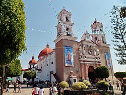
| Santuario de Nuestra Señora de Tonatico | ||
Koordinaten: 18° 48′ N, 99° 40′ W
Tonatico ist ein Municipio im mexikanischen Bundesstaat México. Das Municipio hatte im Jahr 2010 12.099 Einwohner und 3.214 Haushalte; 11 % der Bevölkerung lebten in extremer Armut. Die Fläche des Municipios beträgt 91,7 km².
Verwaltungssitz und größter der 15 Orte des Municipios ist das gleichnamige Tonatico. Die nächstgrößeren Orte im Municipio sind El Terrero und La Puerta de Santiago.
Geographie
Tonatico liegt im Süden des Bundesstaates México, etwa 80 km südwestlich von Mexiko-Stadt, 50 km westlich von Cuernavaca und 50 km südlich von Toluca de Lerdo auf einer Höhe zwischen 1440 m und 2125 m.
Das Municipio Tonatico grenzt an die Municipios Ixtapan de la Sal und Zumpahuacán sowie an den Bundesstaat Guerrero.
Weblinks
- INEGI: Datos Geográficos: Municipio Tonatico (spanisch; PDF)
- Enciclopedia de los Municipios y Delegaciones de México: Municipio Tonatico (spanisch)
Auf dieser Seite verwendete Medien
Coat of arms of Mexico State
Autor/Urheber: Enrique López-Tamayo Biosca, Lizenz: CC BY 2.0
Shrine Our Lady of Tonatico, Tonatico, Mexico state, Mexico
Autor/Urheber: Sarumo74, Lizenz: CC BY 3.0
Logo based on the shield of the municipality of Tonatico belonging to the State of Mexico, based on the one shown in the official website of the municipality and the Municipal Bando Police and Good Government www.edomex.gob.mx/legistelfon/doc/pdf/bdo/bdo110.pdf art. 8


