Mogollon (New Mexico)
| Mogollon | |||
|---|---|---|---|
 Mogollon im Jahr 2008 | |||
| Lage in New Mexico | |||
| |||
| Basisdaten | |||
| Gründung: | 1884 | ||
| Staat: | Vereinigte Staaten | ||
| Bundesstaat: | New Mexico | ||
| County: | Catron County | ||
| Koordinaten: | 33° 24′ N, 108° 48′ W | ||
| Zeitzone: | Mountain (UTC−7/−6) | ||
| Einwohner: | 11 (Stand: 2020) | ||
| Haushalte: | 0 (Stand: 2020) | ||
| Fläche: | 4,64 km² (ca. 2 mi²) davon 4,64 km² (ca. 2 mi²) Land | ||
| Bevölkerungsdichte: | 2 Einwohner je km² | ||
| Höhe: | 2197 m | ||
| FIPS: | 35-49180 | ||
Mogollon ist eine Geisterstadt und ein Census-designated place in Catron County im US-Bundesstaat New Mexico. Die Volkszählung von 2020 erfasste 11 Einwohner.
Lage
Der Ort liegt in den Mogollon Mountains am Silver Creek und der Straße 159 (Bursum Road). Zur Bundesstaatsgrenze mit Arizona sind es nach Westen rund 30 Kilometer. Nach Norden nach Springerville in Arizona und nach Silver City im Süden sind es jeweils etwa 80 Kilometer.
Geschichte
Mogollon entstand Ende des 19. Jahrhunderts als Bergbauort. Mit Schließung des letzten Bergwerks 1952 verwaiste die Stadt. 1973 diente sie als Kulisse für den Italowestern Mein Name ist Nobody. Im nationalen Register für historische Orte ist die ehemalige Stadt als Mogollon Historic District gelistet.[1]
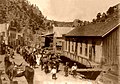 Cinco de Mayo in Mogollon im Jahr 1914
 Bergbaugerätschaft
 Stillleben
 Geschäft
Weblinks
Einzelnachweise
| Villages | Reserve | |
| CDPs | Alma • Apache Creek • Aragon • Cruzville • Datil • Escudilla Bonita • Glenwood • Homestead • Lower Frisco • Luna • Middle Frisco • Mogollon • Pie Town • Pleasanton • Quemado • Rancho Grande • Rivers | |
| Reservate | Acoma Pueblo‡ • Zuni Reservation‡ |

Liste der Städte in New Mexico
Auf dieser Seite verwendete Medien


Autor/Urheber: Cam Vilay, Lizenz: CC BY 3.0
J.P. Holland General Store in the town of Mogollon, NM. Taken in 2006

Autor/Urheber: Tom Blackwell from UK, Lizenz: CC BY-SA 2.0
...put out to pasture beside the main road through Mogollon.

Autor/Urheber: Alexrk2, Lizenz: CC BY 3.0
Diese Landkarte wurde mit GeoTools erstellt.

Autor/Urheber: Tom Blackwell from UK, Lizenz: CC BY-SA 2.0
Looks like it's been a while since this automobile saw a full tank of gas.