Mobile nichtnavigatorische Ortungsfunkstelle
Mobile nichtnavigatorische Ortungsfunkstelle (englisch radiolocation mobile station) ist – entsprechend Artikel 1.89 der Vollzugsordnung für den Funkdienst (VO Funk) der Internationalen Fernmeldeunion (ITU) – definiert als „Funkdienst des nichtnavigatorischen Ortungsfunkdienstes, die dazu bestimmt ist, während der Bewegung oder während des Haltens an beliebigen Orten betrieben zu werden.“[1]
Einordnung
Jede Ortungsfunkstelle wird dem Funkdienst zugeordnet, an dem sie ständig oder zeitweilig teilnimmt. Gemäß VO Funk (Artikel 1) ist diese Funkstell wie folgt einzuordnen: Ortungsfunkstelle (Artikel 1.86) im Ortungsfunkdienst (Artikel 1.40)
- Mobile Navigationsfunkstelle (Artikel 1.87) im Navigationsfunkdienst (Artikel 1.40)
- Ortsfeste Navigationsfunkstelle (Artikel 1.88) im Navigationsfunkdienst
- Mobile nichtnavigatorische Ortungsfunkstelle
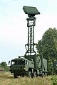
Air Surveillance Radar TRML-3D
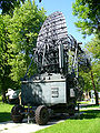
Höhenfinder Radar
RAAF Radar, AN/TPS-77
Radarsensor LÜR der Luftwaffe
MIM-104 Patriot Radar

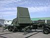
Nike Hercules IFC Radaorsensoren LOPAR, MTR, TTR, und TRR (v. l. n. r.)
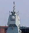
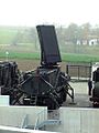
APAR-Radar der Fregatte Hamburg
Waffenleitradar

Maritimes X-Band Radar in Marschlage

Flugzeugradar „Lichtenstein SN-2“ in der ME Bf 110G

Siehe auch
Literatur
- Grünbuch – Frequenzbereichszuweisungsplan für die Bundesrepublik Deutschland und internationale Zuweisung der Frequenzbereiche 9 kHz – 400 GHz. 1994; herausgegeben vom BMPT; BAPT Bestell-Nr. 5010311 001-1
Weblinks
Einzelnachweise
- ↑ VO Funk, Ausgabe 2012, Artikel 1.89, Definition: Radiolocation mobile station/ Mobile nichtnavigatorische Ortungsfunkstelle
Auf dieser Seite verwendete Medien
.jpg)

Autor/Urheber: Butch, Lizenz: CC BY-SA 3.0
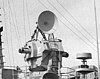
Nike Hercules IFC radars. LOPAR on the left and the three tracking radars (MTR, TTR and TRR) on the right. ITU-classificatio: Radiolocation land station in the radiolocation service.

Cropped version focusing on the manned Mark 68 gun fire control system weapons director with parabolic dish for AN/SPG-53F on top; ITU-classificatio: Radiolocation land station in the radiolocation service.
Original description:A partial starboard view of the guided missile destroyer USS Coontz (DDG-40), showing the ship's superstructure and masts.

(c) Nick-D at the English Wikipedia, CC BY-SA 3.0
AN/TPS-77 der RAAF; ITU-Klassifizierung: ortsfeste nichtnavigatorische Ortungsfunkstelle im nichtnavigatorischen Ortungsfunkdienst.

Autor/Urheber: USN, Lizenz: CC BY-SA 3.0
The Thales Nederland Active Phased Array Radar (APAR), mounted on the German Sachsen class frigate Hamburg (F 220); ITU-classificatio: Radiolocation land station in the radiolocation service.


A Bf 110G-4 Night fighter at the RAF Museum in London. The antennas on the nose are of a FuG 220 Lichtenstein SN-2 radar set (ITU-classificatio: Radiolocation land station in the radiolocation service). Clearly visible are the openings for two 20mm cannons in the lower nose and two 30 mm cannons in the upper nose.

Mobiler Radar Höhenfinder PRW-17 (UDSSR), Index GRAU 1PL141; eine zwei-dimensionale mobile nichtnavigatorische Ortungsfunbkstelle im nichtnavigatorischen Ortungsfunkdienst.

Autor/Urheber: Ministry of National Defence Republic of Lithuania, Lizenz: GFDL
Lithuanian Armed Forces newly-acquired 3D Air Surveillance Radars TRML-3D; ITU-classificatio: Radiolocation land station in the radiolocation service.