Mobile (Arizona)
| Mobile Ortsteil von Goodyear (Arizona) | |
|---|---|
 | |
| Koordinaten | 33° 3′ 23″ N, 112° 16′ 16″ W |
| Eingemeindung | 2007 (Goodyear, Arizona) |
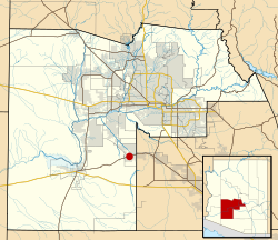
Mobile ist eine unselbständige Siedlung und Ortsteil von Goodyear im Maricopa County im US-Bundesstaat Arizona, 56 km südwestlich von Phoenix (Arizona). Mobile wurde in den 1930er Jahren im Zuge des Eisenbahnbaus als Freedmen’s town für Afro-Amerikanern gegründet. Heute leben dort weniger als 100 Personen, dennoch gibt es eine Grundschule (Mobile Elementary). Der Ort wird von der Arizona State Route 238 in Südwest-Nordost-Richtung tangiert. Westlich liegt das großflächige Naturschutzgebiet Sonoran Desert National Monument.
2007 wurden Mobile und das nördlich anschließende Sonoran Valley mit zusammen rund 170 km² der Gemeinde Goodyear angeschlossen. Grund war das damalige Projekt einer Planstadt für im Endausbau etwa 50.000 Einwohner, das 2009 in der Weltfinanzkrise zusammenbrach. Erst 2019 beschloss Goodyear den Bau einer etwa 25 km langen Straßenverbindung durch das Sonoran Valley, die den Hauptort mit Mobile direkt verbinden würde.[1]
Der private Flugplatz (Koordinaten) des Airline Training Center Arizona befindet sich sechs km nördlich vom Ort. Die asphaltierte Startbahn 09/27 hat eine Länge von 1372 m und wurde von den Flugschülern der Lufthansa und der Bundeswehr zum Üben von Landeanflügen verwendet, die auf dem nahegelegenen Phoenix Goodyear Airport stationiert waren. Sie besitzt zu Übungszwecken ein vollwertiges ILS auf der Landebahn 09.
Einzelnachweise
- ↑ Joshua Bowling: Goodyear gets the OK to build 15-mile Sonoran Valley Parkway. Here's what the city is waiting on. AZ central, 20. Juni 2019
Auf dieser Seite verwendete Medien
This map shows the incorporated areas and Indian reservation boundaries in Maricopa County, Arizona, along with water bodies and major highways and roads. Mobile is highlighted in red. Other incorporated cities are shown in gray, planning area borders for these cities and Indian reservation borders are shown as solid black lines. Changes from Previous Version: Updated the maps to include water bodies and to make "less boring" than the plain black/white/gray maps. Format was updated to match standards laid out by WikiProject Maps/Conventions. Map data is based on data from the following Webpage: Maricopa County Interactive GIS Map. I created this map in Inkscape.
