Mārupe
| Mārupe | |||
|---|---|---|---|
 Hilfe zu Wappen |
| ||
| Basisdaten | |||
| Staat: | |||
| Verwaltungsbezirk: | Mārupes novads | ||
| Koordinaten: | 56° 54′ N, 24° 3′ O | ||
| Einwohner: | 17.796 (2022) | ||
| Fläche: | 18,16 km² | ||
| Bevölkerungsdichte: | 980 Einwohner je km² | ||
| Höhe: | 10 m | ||
| Webseite: | www.marupe.lv | ||
Mārupe (deutsch Marienbach) ist ein südwestlicher Vorort der Stadt Riga in Lettland und Zentrum des gleichnamigen Bezirks (Mārupes novads), der 2009 ohne Gebietsveränderung aus der Gemeinde entstand. Im Jahre 2022 zählte Mārupe gut 18.000 Einwohner.[1]
Bis 2022 war Mārupe das bevölkerungsreichste Dorf Lettlands. Zum 1. Juli 2022 wurden der Gemeinde Mārupe die Stadtrechte zuerkannt.
Sehenswürdigkeiten

Kulturzentrum und Rathaus
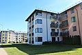
Wohnhäuser

Fluss Mārupīte

Schule
Literatur
- Astrīda Iltnere (Red.): Latvijas Pagasti, Enciklopēdija. Preses Nams, Riga 2002, ISBN 9984-00-436-8.
- Lettland (Südlivland und Kurland). In: Hans Feldmann, Heinz von zur Mühlen (Hrsg.): Baltisches historisches Ortslexikon. Band 2. Böhlau Verlag, Köln / Wien 1990, ISBN 3-412-06889-6, S. 375.
Fußnoten
- ↑ Latvijas Ģeotelpiskās informācijas aģentūra (LĢIA): Vietvārdu datubāze (Datenbank der Ortsnamen), Ausgabe vom 2. Februar 2022 (lettisch).
Auf dieser Seite verwendete Medien


Latvia adm location map.svg
(c) Karte: NordNordWest, Lizenz: Creative Commons by-sa-3.0 de
Positionskarte von Lettland
(c) Karte: NordNordWest, Lizenz: Creative Commons by-sa-3.0 de
Positionskarte von Lettland
.jpg)
Mārupe, houses at Zeltrītu street (N16, 18).jpg
Autor/Urheber: Egilus, Lizenz: CC BY-SA 4.0
Mārupe, houses at Zeltrītu street (N16, 18)
Autor/Urheber: Egilus, Lizenz: CC BY-SA 4.0
Mārupe, houses at Zeltrītu street (N16, 18)

Mārupe, Mārupīte near border with Riga.jpg
Autor/Urheber: Egilus, Lizenz: CC BY-SA 4.0
Mārupe, Mārupīte near border with Riga
Autor/Urheber: Egilus, Lizenz: CC BY-SA 4.0
Mārupe, Mārupīte near border with Riga
.jpg)
Mārupe school (oldest part built 1824, others 2000, 2008).jpg
Autor/Urheber: Egilus, Lizenz: CC BY-SA 4.0
Mārupe State gymnasium, Mārupe, Kantora street 97
Autor/Urheber: Egilus, Lizenz: CC BY-SA 4.0
Mārupe State gymnasium, Mārupe, Kantora street 97
.jpg)
Mārupe, Culture house (former House of Defenders, 1936).jpg
Autor/Urheber: Egilus, Lizenz: CC BY-SA 4.0
Mārupe, Culture house (former House of Defenders, 1936), in new part right - town hall
Autor/Urheber: Egilus, Lizenz: CC BY-SA 4.0
Mārupe, Culture house (former House of Defenders, 1936), in new part right - town hall